Table of Contents

Welcome!

Welcome to the MERMAID Documentation. Here we will walk you through how to use MERMAID.

MERMAID is an open-source application that collects and manages real-time coral reef health data, developed in partnership between the WCS, WWF, and Sparkgeo.

With MERMAID, scientists input their observations straight into the platform using the Web app. MERMAID does the job of tagging and sorting data, avoiding duplicates, standardizing scientific names and summarizing critical indicators.

We save you time so you can save coral reefs!

MERMAID joins you in the field with its off-line capabilities, but it stands apart from Excel or personal database apps like Access because it requires virtually zero post-entry data clean up! 

Users can select reef fish and coral names from a standard list of taxa with only a few keystrokes; MERMAID will autocomplete the rest. Selecting names means saving time typing in species names or cleaning up typos of misspelled species names.

MERMAID also allows you to calculate reef fish biomass while you type, or see your total coral cover as soon as you have finished entering a transect. When you have finished collecting data, it can be exported to standard field reports (Excel) and used to create graphs or other reports. You can also analyze your data by accessing it directly from MERMAID using the mermaidr package.

Welcome!

The MERMAID workflow

The MERMAID workflow:

  1. Sign up and set up a project

    1. Sign up for an account

    2. Set up a project and add users

    3. Prepare for off-line use

  2. Collect data

    1. Select a transect type

    2. Enter site information

    3. Enter management regime

    4. Include benthic attributes and fish species

    5. Complete and save the transect

  3. Review and submit 

    1. Validate data

    2. Address errors and warnings

    3. Submit data

  4. Export and analyze data

    1. Export to .XLSX for further analysis

    2. Analyze directly using mermaidr

Questions? You can reach out to us when online via the Contact link at the bottom of the app. An off-line (pdf) version of this documentation is available through the "Download" button at the left menu bar.

Enim fermentum dolor molestie egestas ultricies. Curabitur consectetuer risus justo fames posuere bibendum praesent elementum diam facilisis montes.

  1. Nascetur luctus adipiscing sollicitudin.
  2. Primis mi ornare scelerisque ultrices vestibulum.
  3. Adipiscing augue taciti fames hac eleifend ut.

Platea blandit eleifend ut imperdiet netus quam quisque nostra et. Congue faucibus nascetur facilisi malesuada nibh gravida semper massa a torquent.

  1. Natoque odio letius ligula massa ex eu aliquet per.
  2. Mi nostra fames torquent ad etiam sociosqu.
  3. Integer tellus hendrerit.

import $ from "jquery";

$(() => {
    var prevScrollpos = window.pageYOffset;
    window.onscroll = function () {
        var currentScrollPos = window.pageYOffset;
        if (prevScrollpos > currentScrollPos) {
            $(".kmp-header").addClass("is-show");
        } else {
            $(".kmp-header").removeClass("is-show");
        }
        if ($(this).scrollTop() == 0) {
            $(".kmp-header").addClass("is-show");
        }
        prevScrollpos = currentScrollPos;
    };
});
# Python program to check if the input number is odd or even.
# A number is even if division by 2 gives a remainder of 0.
# If the remainder is 1, it is an odd number.

num = int(input("Enter a number: "))
if (num % 2) == 0:
   print("{0} is Even".format(num))
else:
   print("{0} is Odd".format(num))
benthic_data <- projects_public_benthic %>%
  mermaid_get_project_data("benthicpit", "sampleevents", token = NULL)

head(benthic_data)
#> # A tibble: 6 × 61
#>   project             tags  country site  latitude longitude reef_type reef_zone
#>                                         
#> 1 2022 DamaWISH endl… WCS … Fiji    DamC1    -16.8      179. patch     back reef
#> 2 2022 DamaWISH endl… WCS … Fiji    DamC3    -16.8      179. patch     back reef
#> 3 2022 DamaWISH endl… WCS … Fiji    DamC4    -16.9      179. patch     back reef
#> 4 2022 DamaWISH endl… WCS … Fiji    DamC5    -16.9      179. patch     fore reef
#> 5 2022 DamaWISH endl… WCS … Fiji    DamC8    -16.8      179. patch     fore reef
#> 6 2022 DamaWISH endl… WCS … Fiji    DamE1    -16.9      179. patch     back reef
#> # ℹ 53 more variables: reef_exposure , tide , current ,
#> #   visibility , management , management_secondary ,
#> #   management_est_year , management_size , management_parties ,
#> #   management_compliance , management_rules , sample_date ,
#> #   depth_avg , depth_sd ,
#> #   percent_cover_benthic_category_avg_sand ,
#> #   percent_cover_benthic_category_avg_rubble , …


A Deeper Dive into MERMAID V2

MERMAID has a fresh design and smarter performance. Dive into everything you need to know about the new MERMAID!
Take a tour of MERMAID version 2 in our latest webinar

The Projects Page

The Projects Page provides a complete summary of what is happening in each project: the number of submitted and unsubmitted sample units, the total number of sites with data, the number of users added to the project, and how the per-protocol data sharing policies have been set. Click on each to go directly to the specific project page; for example, you can access a project's Submitted data page by clicking Submitted. MERMAID Version 2 also added an all-new notification area in the menu (the "bell") that informs you of the latest updates from MERMAID and your projects. Close to the notification button, you can find the Reference button which you can access from any page. Now, you can download References in XLSX format and have all the benthic and fish data in one document. Each project also includes the Copy project and Off-line Ready buttons from MERMAID Version 1.

A Deeper Dive into MERMAID V2

The Overview Page

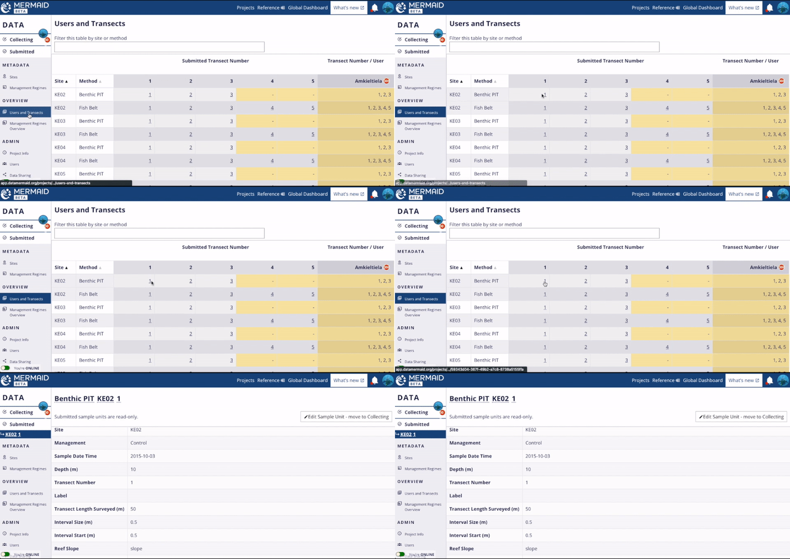
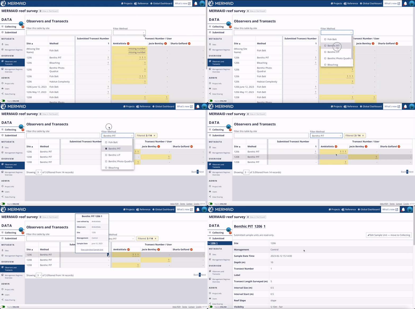
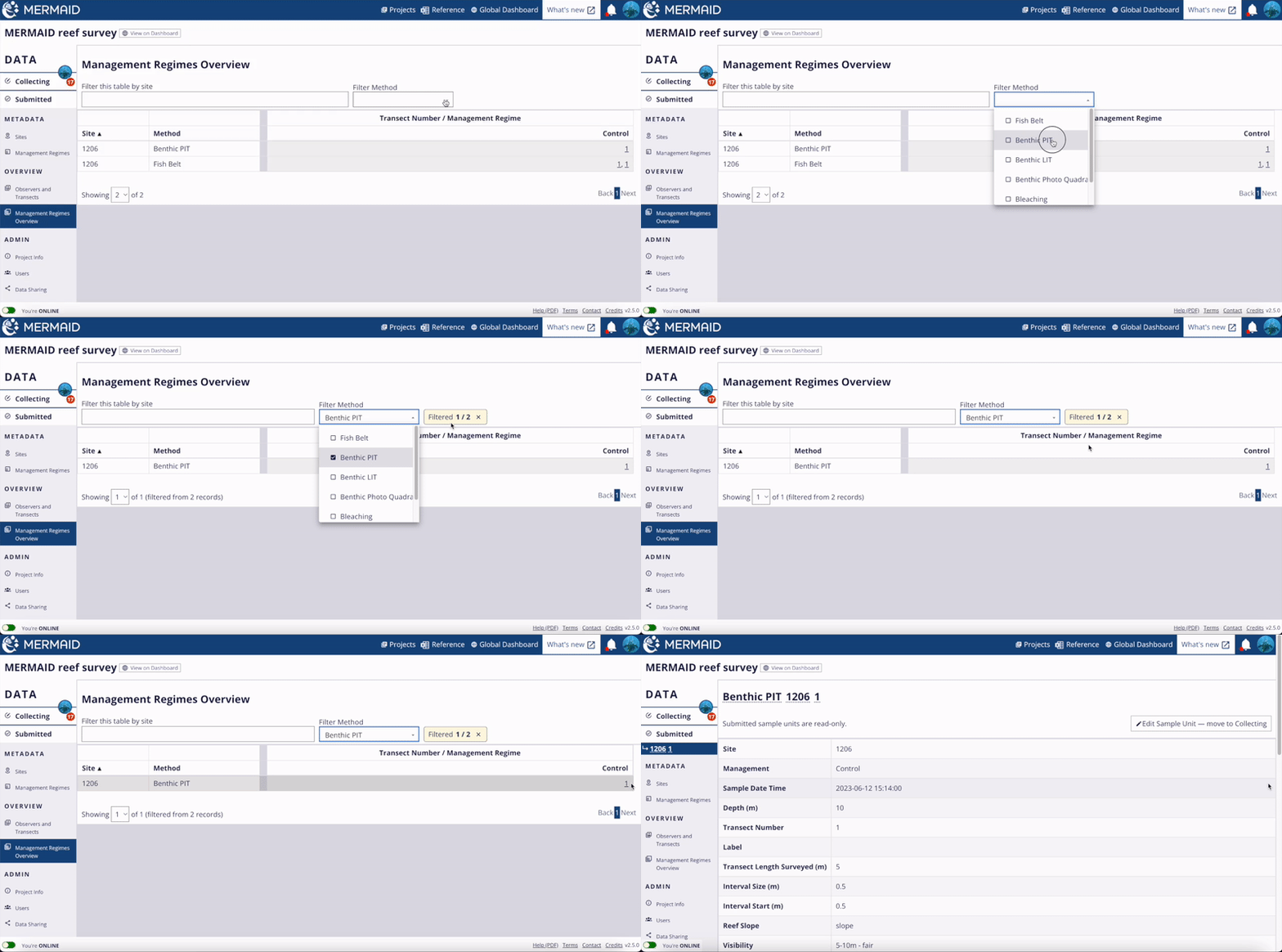
As a data manager, you might want to see at a glance all the data that has been submitted as well as who to chase for unsubmitted data. MERMAID Version 2 understands you. It now has Overview pages that allow you to inspect the number of submitted sample units per method for each site as well as who has not yet submitted which sample units, and make sure that sites are associated with the right management regimes. Clicking on any sample unit number provides you with direct access to that sample unit. To make changes, the sample unit must be moved from the Submitted to the Collecting page. Re-validation is required before submitting the updated sample unit. This means no more unexpected site changes or other unintended errors.

A Deeper Dive into MERMAID V2

The Overview Page showing submitted and unsubmitted data

The Collecting Page

The new Collecting Page is designed to allow users to handle warnings and errors more easily. It also shows a reminder of why a sample unit cannot be submitted, to help you address problems more quickly. Messages are easier to read and appear next to the field where the problem is. MERMAID Version 2 also deals with site and management regime duplications in a smarter way; Version 1 would check for duplication every time a site or management regime was saved, whereas in Version 2, duplication is checked only with sample unit validation, and only against submitted sample units -- a more efficient and more relevant process. The photo transect method is now available in MERMAID Version 2 to store your photo classification results. On the Submitted page, the Export to XSLX button now produces a single file with data aggregated to sample unit and sample event levels as well as raw observations.

A Deeper Dive into MERMAID V2

The Users Page

The new Users page provides more detailed information on users in the project, for teams of any size. MERMAID Version 2 supports filtering users by name or email address. Admins can also change roles, add and remove users without going to another page, and access the user's email addresses for easy contact.

A Deeper Dive into MERMAID V2

See our MERMAID Version 2 announcement. If you have any questions or want to learn more about MERMAID Version 2, contact us.

Getting started

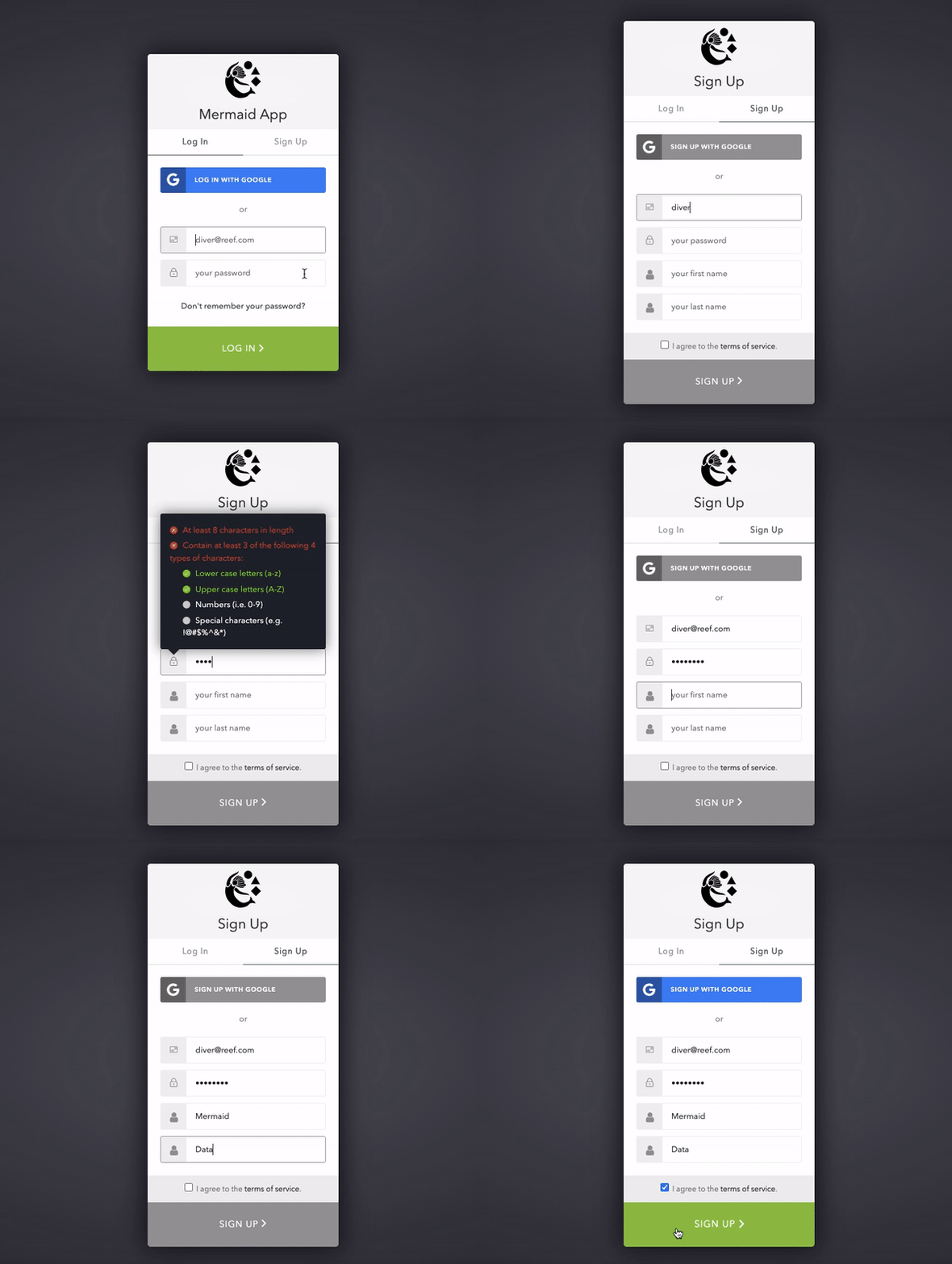
Signing up

To use MERMAID,  you need to sign up at https://app.datamermaid.org.

You can 'sign up with Google' to use an existing Gmail account and associated password, or enter a different email and create a password specific to MERMAID. Your account will be linked to your email.

Only users who have a MERMAID account can collect data on MERMAID. Emails not associated with MERMAID accounts can be specified by other users as Sample Unit observers; but without an account you cannot interact with the data.

MERMAID is only officially supported on Google Chrome, Firefox, and Edge browsers, and may not fully work with other browsers, like Explorer or Safari.

After signing up you will receive a confirmation email to verify your new account. You can access your profile information by clicking on the avatar in the upper right corner of any page. Here you can view your email and name, and change your MERMAID account name.

Signing up

Signing up to our MERMAID page

If you forget your unique password for MERMAID, click 'Don’t remember your password?' on the login page to receive an email with a link to reset your password.

If you signed up for MERMAID using Google and forget your Gmail password, you must reset your password through Google.

$(function(){
    if (localStorage.getItem('cookieSeen') !== 'shown') {
        $('#cookie-consent-banner').removeClass('hidden');
    }

    $('#cookie-accept').click(function() {
        $('#cookie-consent-banner').addClass('hidden');
        localStorage.setItem('cookieSeen','shown')
    });
});
$('.changelogs .version .desc').each(function(){
            let str = $(this).html();
            const regex = /(`.*?`)/g;
            str = str.replaceAll(regex, '$1');
            str = str.replaceAll('`','');
            $(this).html(str);
        });

Setting up a new project

A project consists of a set of observations collected in sample units (transect/quadrat/etc.) surveyed at particular sites, on particular dates, associated with management regimes. All data, data sharing, and user access in MERMAID is organized by project. It is up to you to decide how to organize your observations; many users define a project as containing the data from a single expedition.

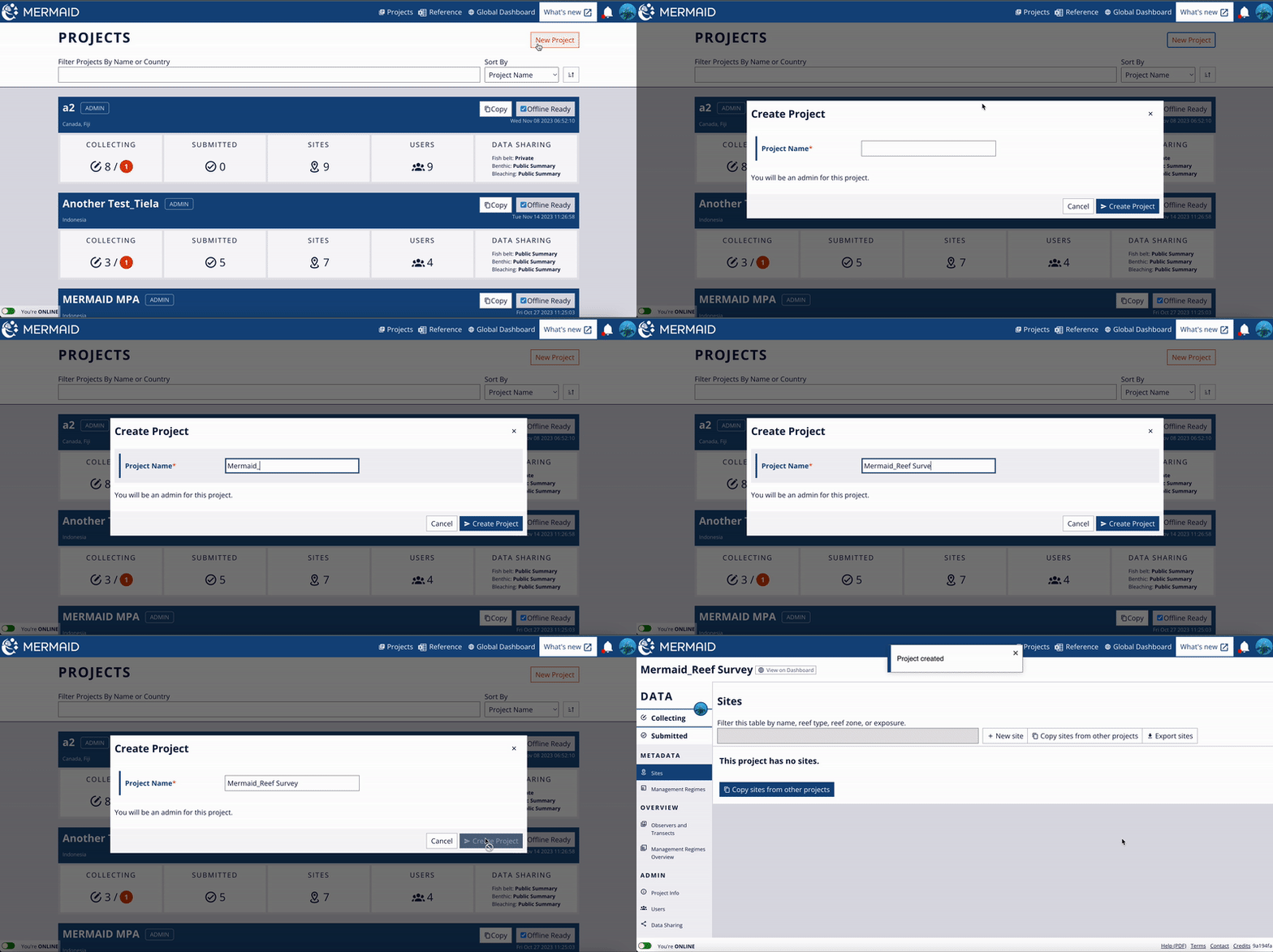
A new project can only be created while online. To create, click the red ‘New Project’ button, enter a project name, then click “Create Project” to complete your new MERMAID project. A name is required for every new project. All other information can be added using "Project Info" in the lefthand menu.

After a project is created, add users, sites, management regimes, and organization, and set data sharing policies while online.

Setting up a new project

Creating a new project.

1. Add Users:

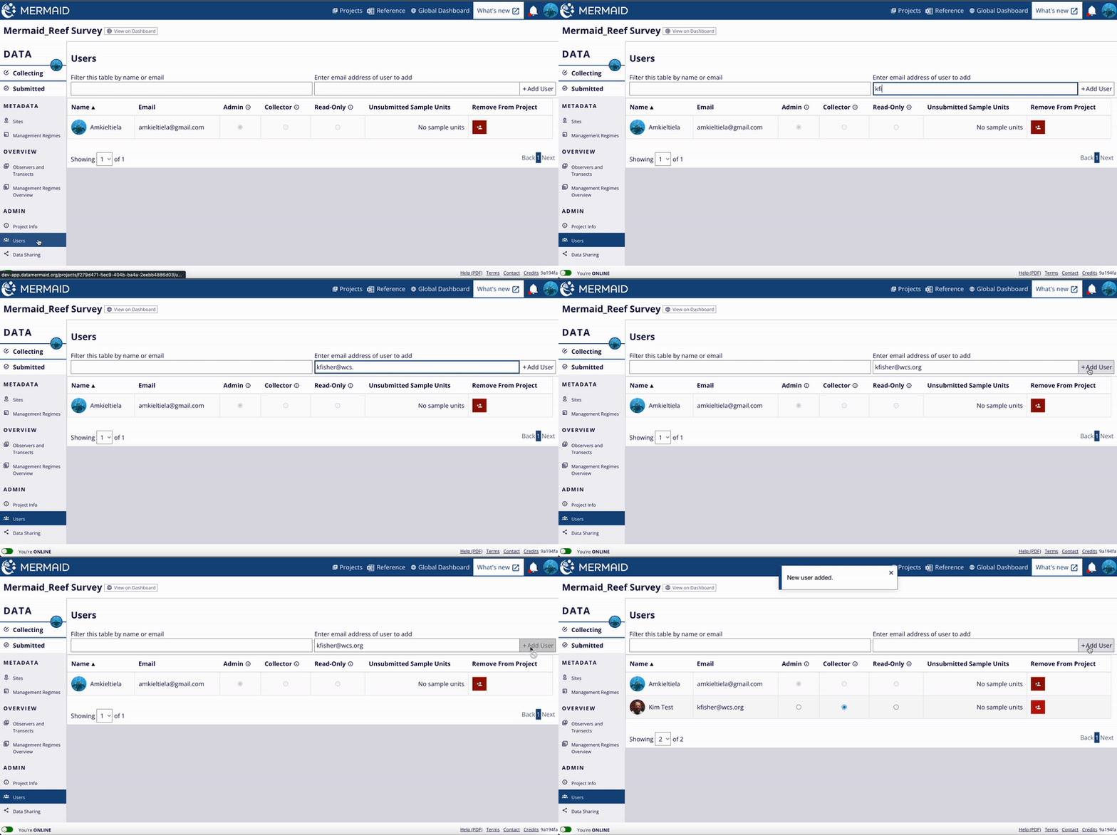
Enter the email addresses for users involved in the project and select their roles. Users should be signed up for a MERMAID account before they can be added to a project. You can add an email that has not yet been associated with an account, but that project user's name will appear as '(pending user)' and they will not be able to access MERMAID until they associate that email with an account.

Setting up a new project

Adding user(s) to the project.

The project creator is automatically the administrator (‘admin’) of the project. Other users will default to the collector role when added and can be changed to admin or read-only by selecting the appropriate role from the available options. Additional users can be added or deleted by the administrator after a project is created.

The scope of each role is as follows:

  • Read-Only: user can only view, export, and analyze data in the analysis tools, but cannot collect new observations.

    • i.e. a project manager who is in charge of writing reports or analyses but is not collecting data in the field

  • Collector: user can view, export, and analyze data, and collect new observations. Once a transect is submitted, the user can no longer edit or delete observations.

    • i.e. a member of the project team who is tasked with collecting data

  • Admin: user has all Collector privileges, and can additionally change project information and data sharing, add and remove project users, transfer unsubmitted sample units between project users, and un-submit sample units for further editing.

    • i.e. typically one person designated as the lead of the project

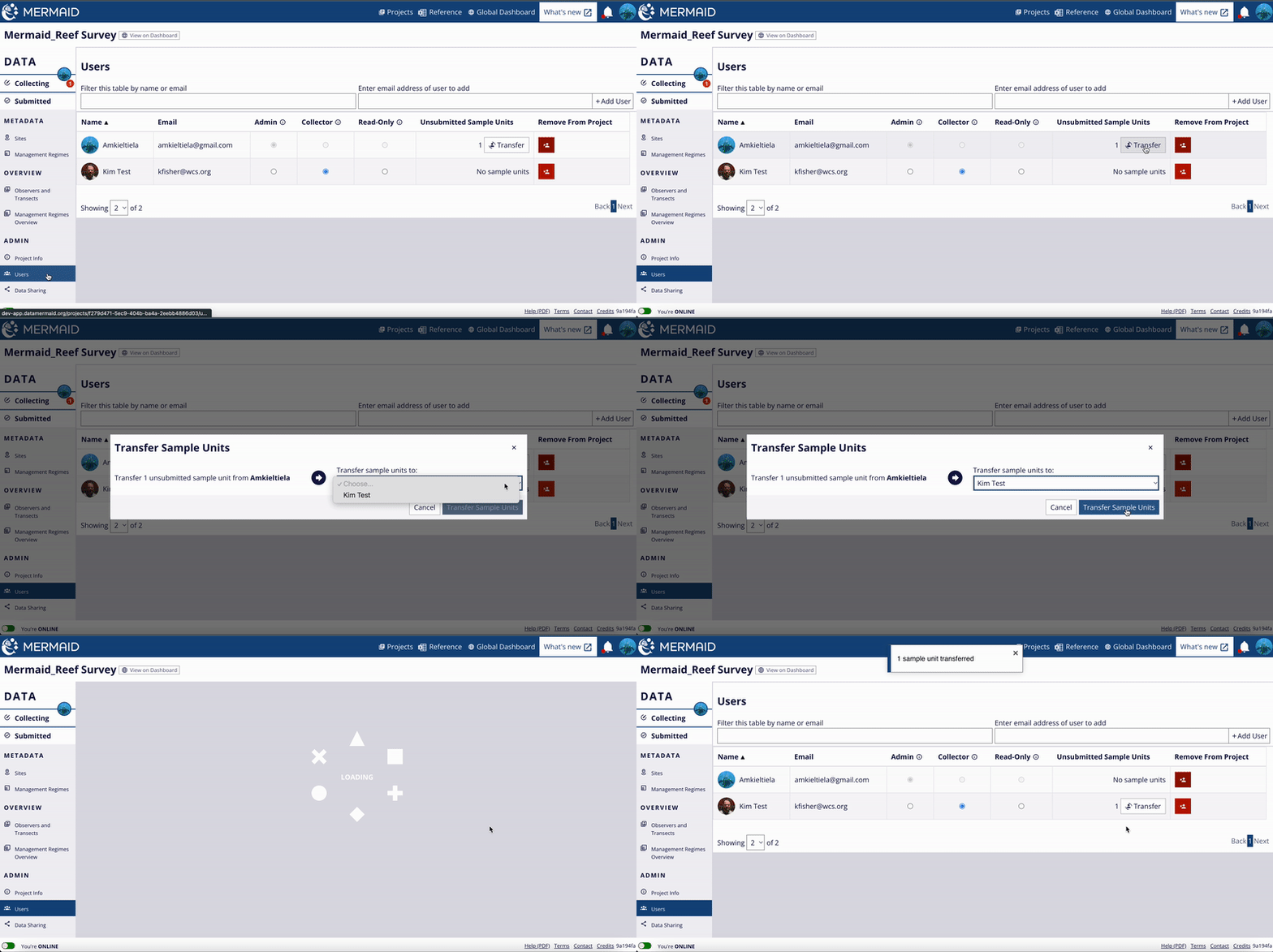
If a user must leave a project or reaches the end of their position, their data can be transferred to other users within a project. This can be done within a project through the "Users" tab. Simply select ‘Transfer’ for the user that will be removed from the project, then indicate the user from the project to whom you would like to transfer the unsubmitted sample units. Users can also be removed from a project on this page. If a user still has unsubmitted sample units on their “collecting” page, be sure to transfer records prior to removing them from the project.

Setting up a new project

Transfer unsubmitted sample unit(s) to another user.

2. Add Sites:

Adding sites to a project is done after the project has been created, by selecting the "Sites" item under "METADATA" in the lefthand menu within a project. Once on the sites page, there are two ways to add a site to a project:

  1. Create a new site using the "+ New site" button at the top right of the page, fill in the details and click the 'Save' button on the top right of the page.

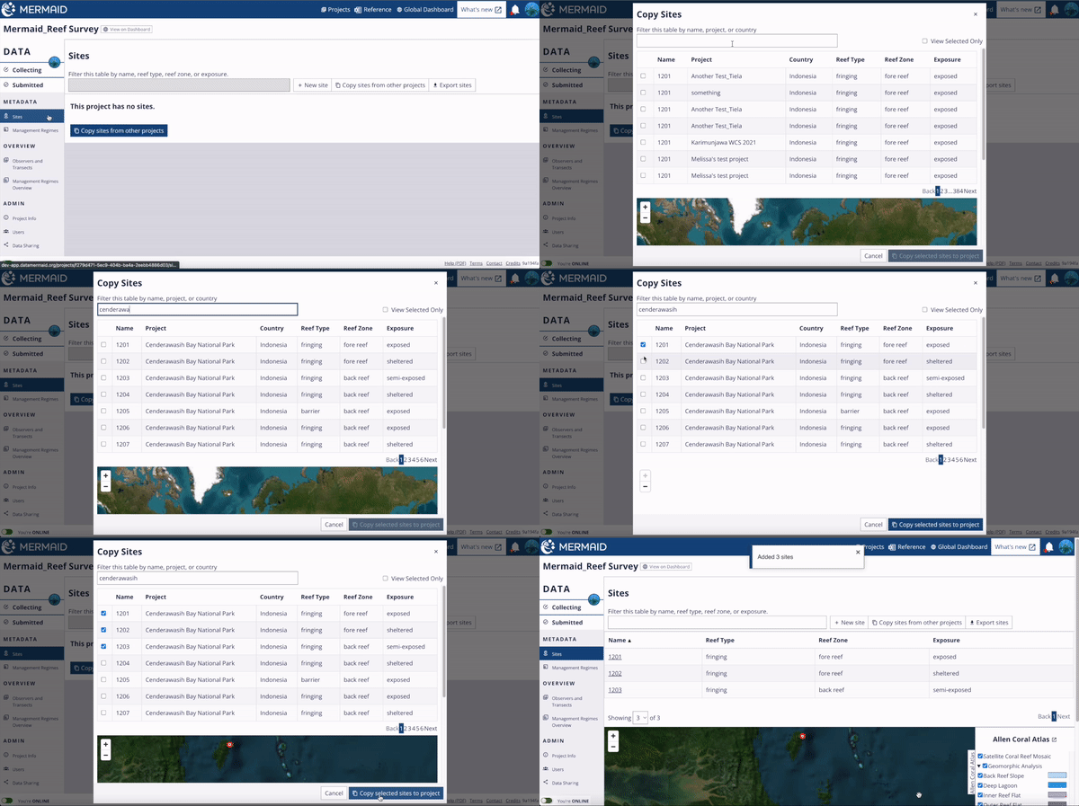
  2. Choose from sites that are already in the MERMAID system using the "Copy sites from other projects" button next to the create new site button. These may be sites that you or your organization are monitoring and have used before in previous surveys. The search bar allows you to filter the list by site name, project name, or country. Click the check box next to any site you would like to add to your project, then click the “Copy selected sites to project” button at the bottom of the dialog. A map at the bottom of the dialog also displays where the site is located with a red dot.

Setting up a new project

Adding site(s) by selecting from existing sites in MERMAID.

3. Add Management Regime:

A management regime categorizes the regulations and restrictions placed on an area in which a survey site is located, on the date of the survey. These may be management regimes for sites that you or your organization are monitoring or have used in previous surveys. To add management regimes, navigate to "Management Regimes" in the lefthand menu within a project. 

If you are surveying sites with a new management regime, or if your site’s management regime has changed, it must be added after creating your new project. 

There are two ways to add management regimes to a project:

  1. Create a new management regimes using the "+ New MR" button at the top right of the page, fill in all the details, and then click 'Save' on the top right of the page.

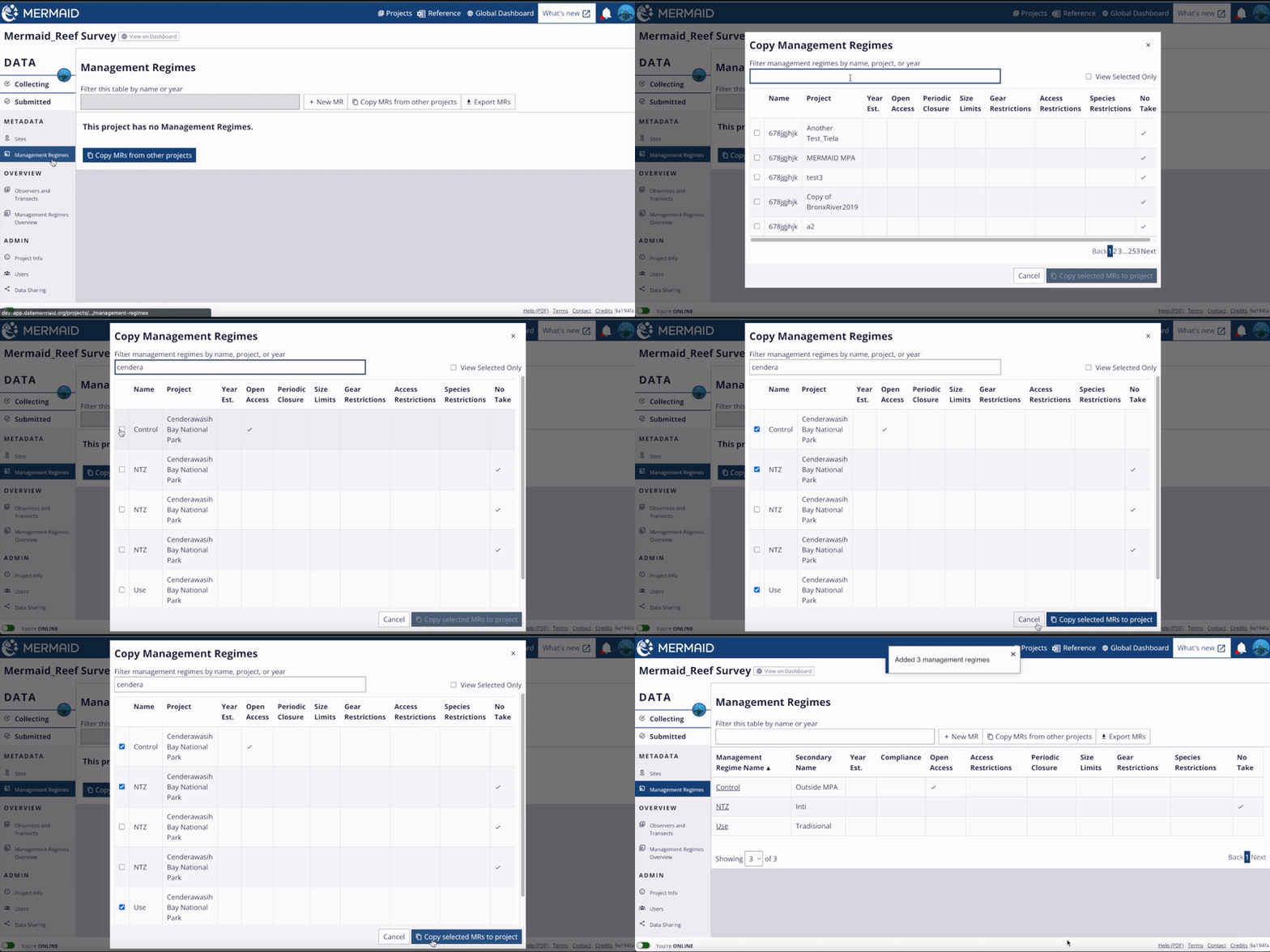
  2. Choose from existing management regimes in the MERMAID system using "Copy MRs from other projects". You can save time by selecting and adding previous management regimes to your project here. The ‘Filter’ bar allows you to search the list by management name, project name, or year. Click the check box next to any management type you would like to add to your project, then click the “Copy selected MRs to project” button at the bottom of the dialog.
Setting up a new project

Adding management regime(s) by selecting from existing management regimes in MERMAID.

4. Add organization

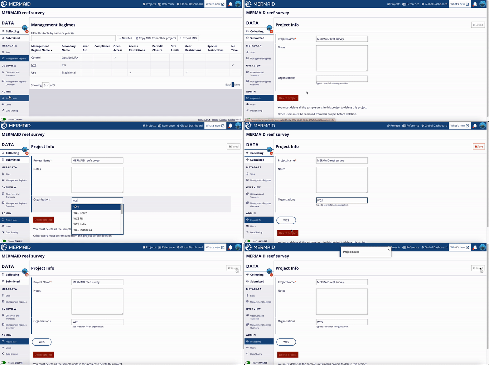
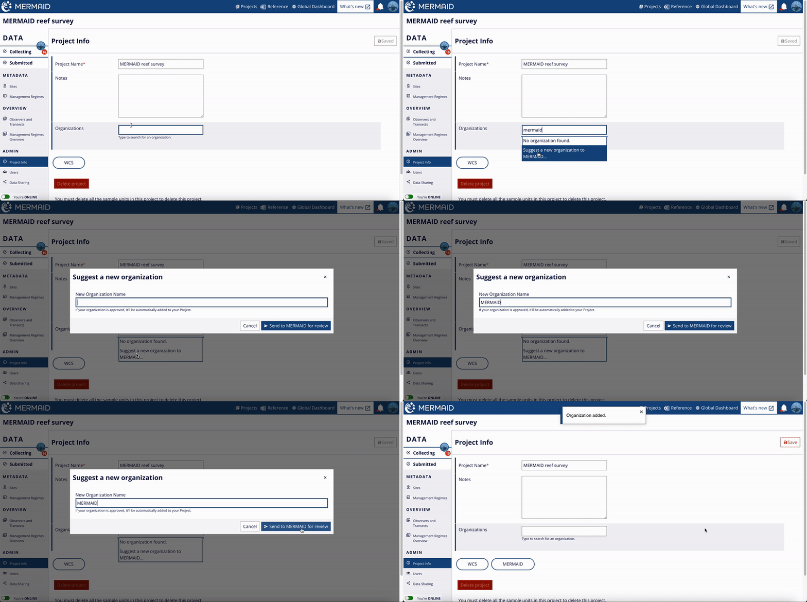
Add your organization to the project. By adding your organization, it will help you monitor your surveys easily by using the filter function on the MERMAID dashboard. To add your organization, use the "Project Info" item under "Admin" in the lefthand menu within a project. As soon as you type, MERMAID will show you a dropdown options of the available organizations for you to select. You can add more than one organization in a project. Once you're done adding organizations, click the "Save" button on the upper right to record your changes.

Setting up a new project

Adding organization to a project.

If you can't find your organization under the available options, you can suggest a new organization. To do this, type your organization name in the "Organizations" field and select "Suggest a new organization to MERMAID" option. Type again your organization name in the "New Organization Name" field and click "Send to MERMAID for review". Once your organization is accepted, it will be available in the dropdown list.

Setting up a new project

Suggesting a new organization.

5. Data Sharing:

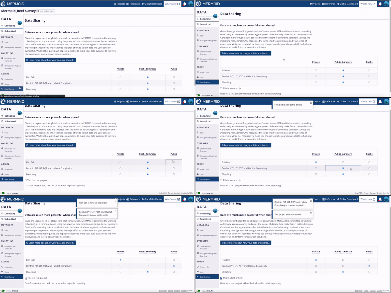
MERMAID is committed to working collectively as a community of researchers and reef managers to use the power of data to make faster, better decisions. Coral reef monitoring data is collected with the intent of advancing coral reef science and improving management. We recognize the large effort to collect data and your sense of ownership. While not required, we hope you choose to make your data available to fuel new discoveries and inform conservation solutions.

Choosing a data policy for your project determines how much of your project’s data can be shared with other users to facilitate global collaboration and understanding of coral reef health via future global dashboard features in MERMAID. It can be chosen independently for different survey methods, so that fish and benthic data can have different levels of sharing. Your data policy level can be changed at any time after creating a project.

The three policy levels are:

  • Public summary – Collected observations are private, but site-level summary statistics are public, along with metadata for the project, protocol, and site. This option is the default.

  • Public – All collected observations are public.

  • Private – Collected observations and site-level summary statistics are private, but metadata for project, protocol, and site, including site location and type and count of sample unit at each site, are public.

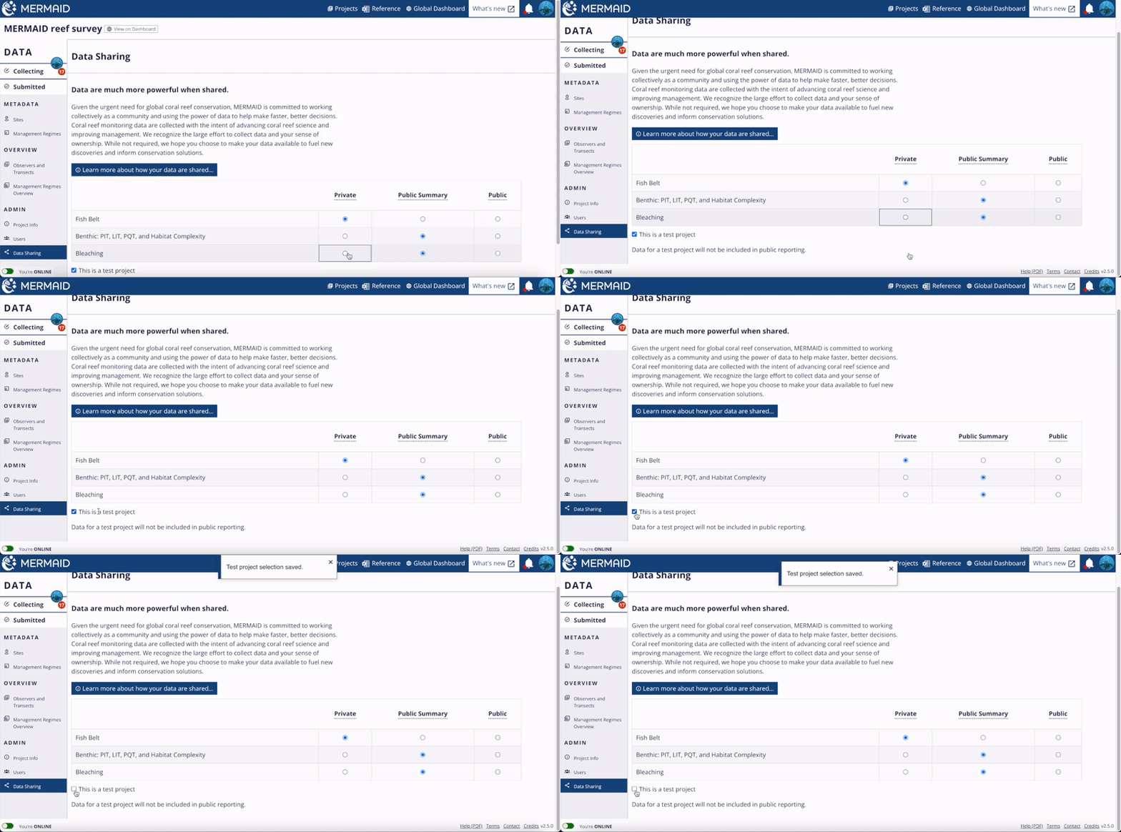
If you are creating a project to practice using MERMAID or train others, you can indicate this with the 'This is a test project' checkbox at the bottom of the page. Data added for a test project will be omitted from all public reporting.

Setting up a new project

Set your data sharing options or assign a project as a test project on the Data Sharing Page.

Now your project is ready to be used!

The Projects page

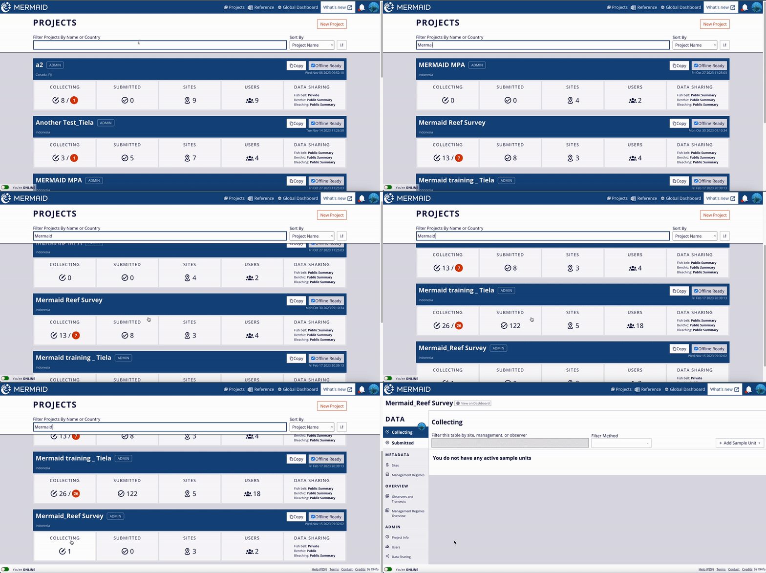
The Projects Page lists all the MERMAID projects of which you are a part, in any role (admin, collector, or read-only). The Projects Page provides a complete summary of what is happening in each project: the number of submitted and unsubmitted sample units, the total number of sites with data, the number of users added to the project, and how the pre-protocol data sharing policies have been set. If you are an admin of a project, there will be an Administrator Tag appear next to the project name.

Click the top-left “MERMAID” icon or “Projects” in the top navigation bar of any page to go to your main Projects page.

Project details can only be edited while online.

The Projects page

Access the Collecting Page, Submitted Page, Sites Page, and Data Sharing Page directly from the Project Page.

You can access common project pages directly by clicking each item under each project. For example, if you click COLLECTING, you will be directed to that project's Collecting page. In this way, the Projects page provides easy access to directly start entering data, review submitted sample units, manage your sites, remove or add additional users, and change your data sharing settings for each project.

If you're doing a repeat survey and would like to create a new project for it, you can use the Copy button on the project you want to copy. This will create a new project and copy the sites, management regimes, data sharing policies, and users and their roles.

Use the filter bar to search the projects by name or country. You can also download a Reference xlsx file containing the fish and benthic attributes used in MERMAID, go to the Global Dashboard, view the What's New page, and check updates using the notification (bell) icon.

Preparing for offline use

Before heading to the field, there are a few steps that must be followed to ensure you are able to enter data offline.

Be sure to follow each step carefully prior to your expedition while connected to the internet:

  1. All project members create accounts

  2. A project admin creates the project

  3. The project admin must add all other users to the project. Optionally, copy or add sites and management regimes before going to the field.

  4. Ensure that the 'Offline Ready' button to the right of each project in the project list that you will use offline has a checked sign. If it is not checked, click the 'Offline Ready' button to make sure data is available offline. 

  5. Test offline access by clicking the 'You're ONLINE' toggle on the bottom left of all pages so that it reads 'You're OFFLINE', turning off your Wi-Fi, restarting Chrome, and entering test data into your project.

  6. Ensure that you and all other project members are logged in to MERMAID and can access the project with all the latest sites and management regimes, then toggle the 'You're ONLINE' button to 'You're OFFLINE'. Do not sign out of your MERMAID account. Now your project is ready to be used offline and it is safe to turn off your computer.
Preparing for offline use

Click the 'Offline Ready' button and toggle the 'You're ONLINE' button to prepare for offline use.

Global Fund for Coral Reefs

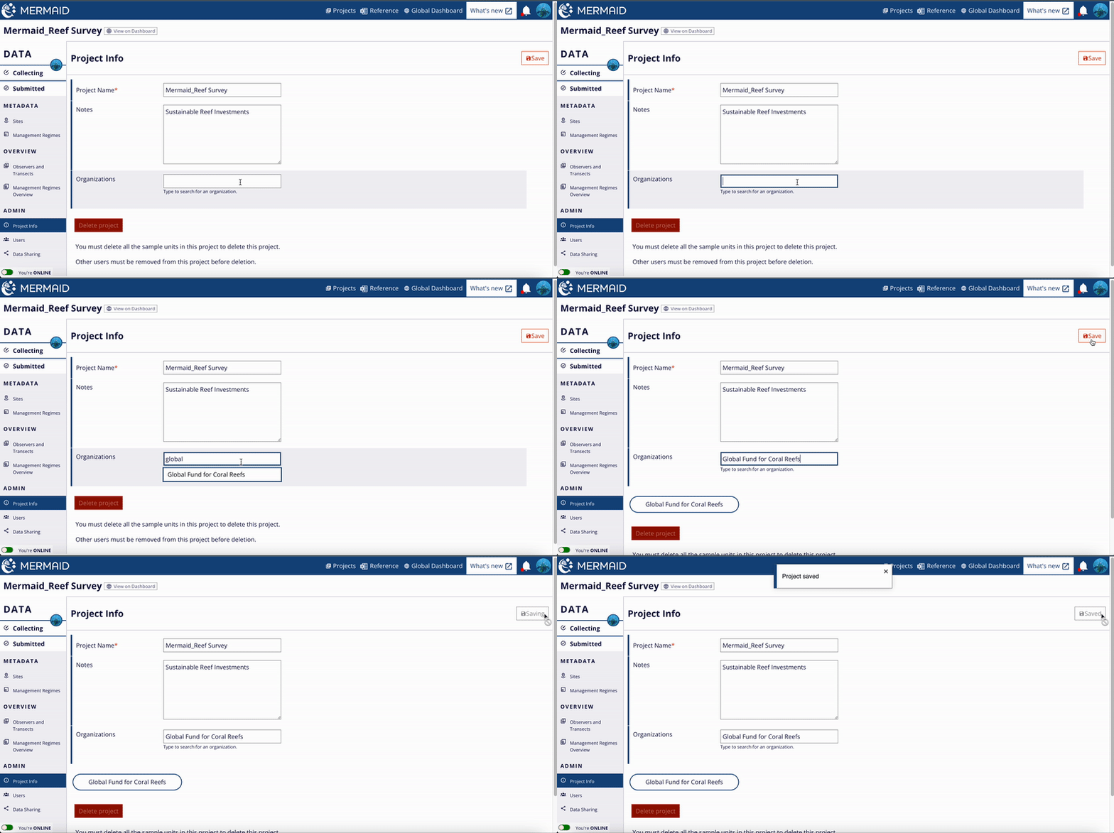
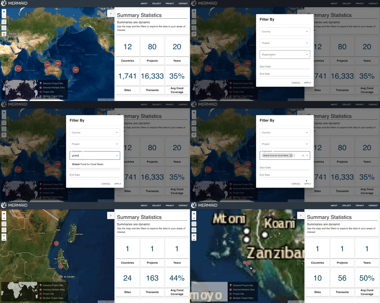
MERMAID supports the Global Fund for Coral Reefs, a blended finance instrument to mobilize action and resources to protect and restore coral reef ecosystems. To set up a GFCR project, simply add 'Global Fund for Coral Reefs' as an organization on your project's 'Project info' page. Projects support multiple organizations.

Global Fund for Coral Reefs

Adding Global Fund for Coral Reef in the Organizations field.

To view all projects tagged with Global Fund for Coral Reefs:

1. Go to the MERMAID dashboard

2. Select the 'filter' icon on the left toolbar

3. Filter organization to 'Global Fund for Coral Reefs'

Global Fund for Coral Reefs

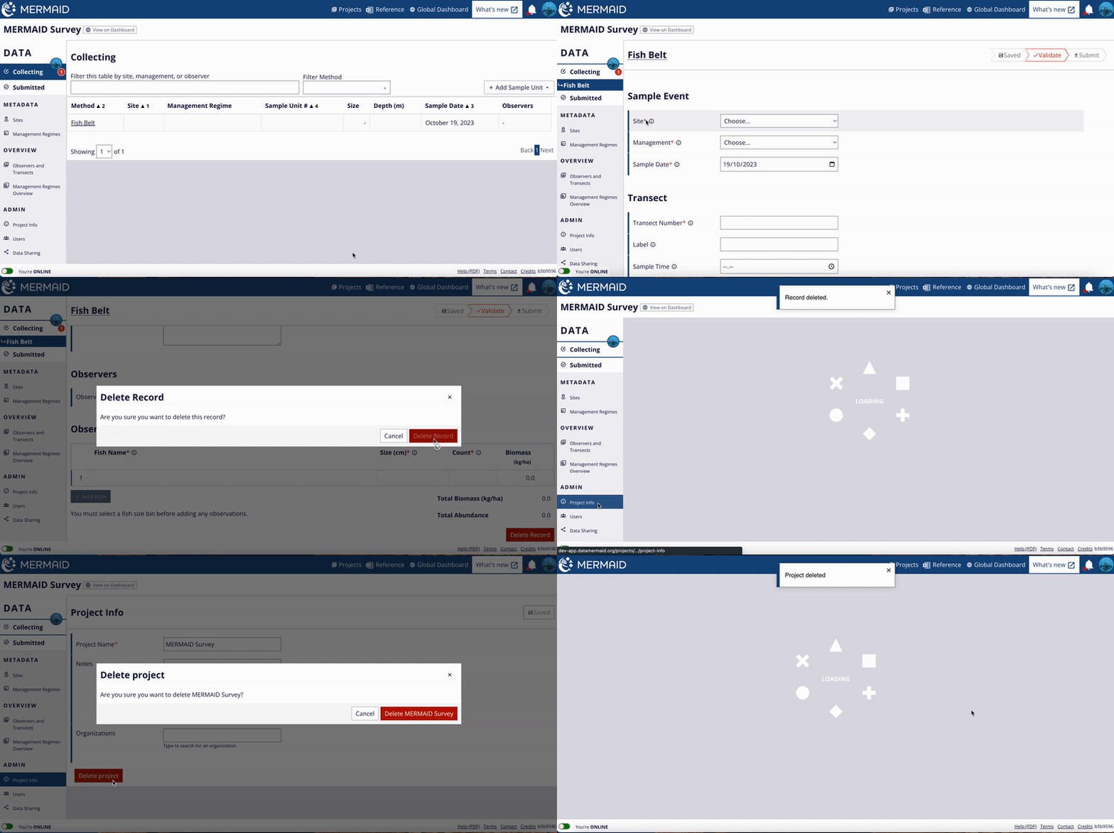
Delete Projects

Delete Projects

Steps to delete a project.

Fish and benthic taxonomies

Click on 'Reference' in the main toolbar (upper right of the MERMAID Collect app) to download an xlsx file of all benthic attributes and fish species / genera / families that are used in MERMAID. This works offline as well as online.

Fish and benthic taxonomies

Download the Reference xlsx from the MERMAID toolbar of Collect (online or offline).

In the xlsx file, you will find five sheets: Fish Families, Fish Genera, Fish Species, Fish Groupings, and Benthic. Each sheet provides information for that taxonomic level. Using filters, you can search and sort for the specific information you are looking for.

Fish and benthic taxonomies

The Reference mermaid_attributes.xlsx spreadsheet includes different sheets for fish and benthic attributes available for use in MERMAID.

Fish and benthic attributes in MERMAID are standardized, and aligned with accepted names in the World Register of Marine Species (WORMS), eliminating discrepancies between different users' data. However, if you want to record an observation of something you think is missing, you can propose to add it in the app, and it will be reviewed by the MERMAID team. Before adding a new fish or benthic species, please make sure that you are using the accepted scientific name by WORMS.

Once you propose a new fish species or benthic attribute, you can directly use it while entering data. The MERMAID team will either accept your proposal, making it available for all other MERMAID users, or work with you to normalize the proposed species or attribute with an existing one; either way, we will let you know by email.

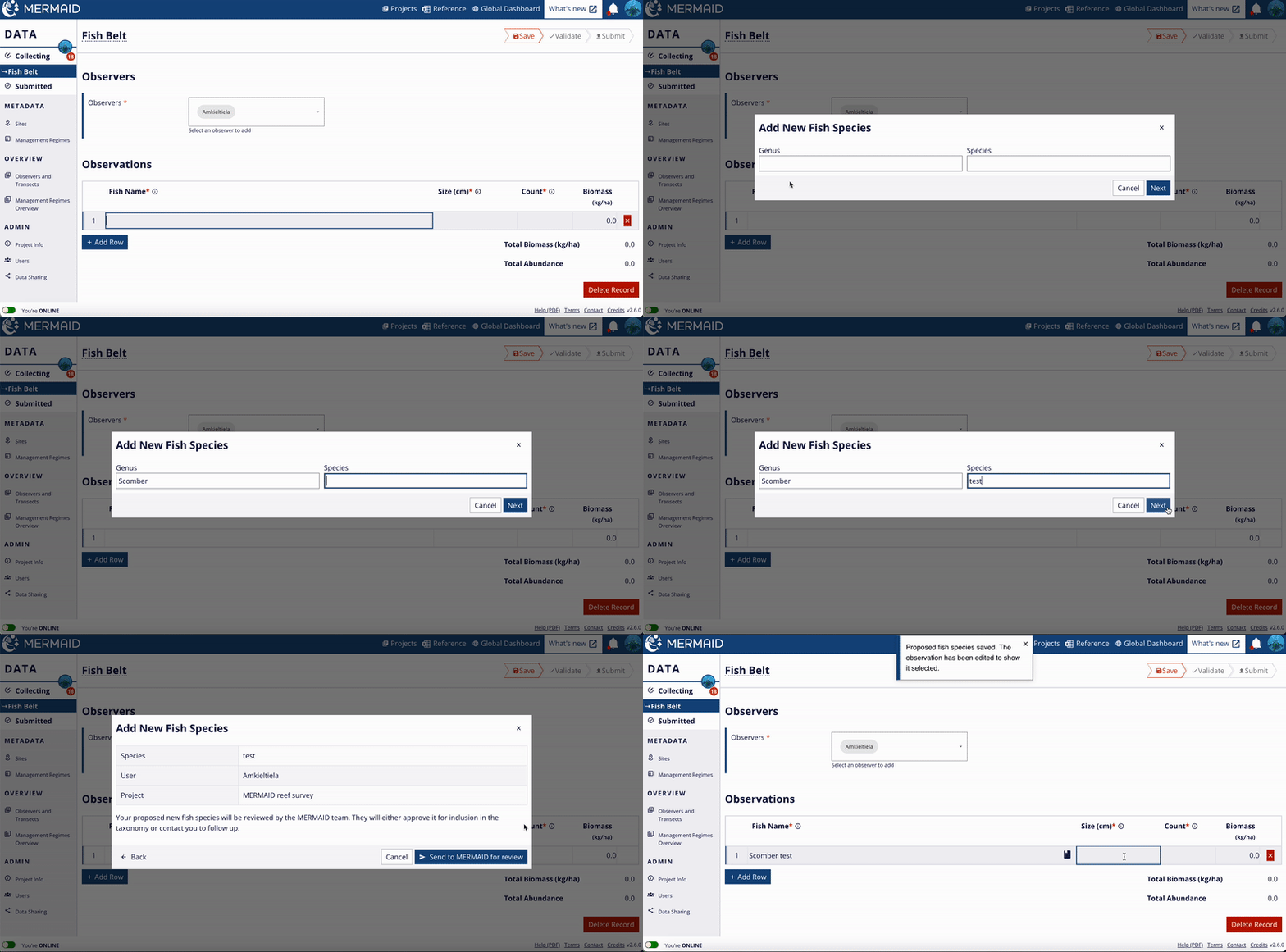
Propose new fish species

  1. In any fish belt transect, scroll down to the Observations table.

  2. Type the fish species that you want to add. When what you have typed does not match any fish species in MERMAID, the option to propose a new species will appear.

  3. Click the “Propose New Species” option.

  4. Type the genus name in the Genus field. If the genus you are looking for is not there ("No results found"), send us an email by clicking “Contact” button in the bottom right of the app.

  5. Type the species name in the Species field and click "Next".

  6. Click "Send to MERMAID for review" to complete your proposal.

Fish and benthic taxonomies

Proposing a new fish species in MERMAID.

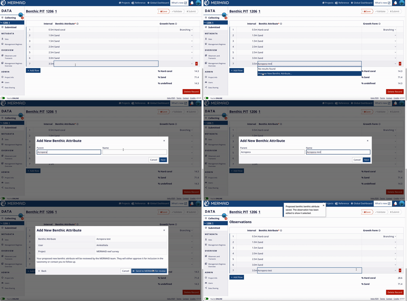
Propose a new benthic attribute

  1. In any benthic transect, scroll down to the Observations table

  2. Type the benthic attribute that you want to add. When what you have typed does not match any benthic attribute in our database, the option to propose a new benthic attribute will appear.

  3. Click the “Propose New Benthic Attribute” option.

  4. Type the parent name in the Parent field. Typically, "Parent" will be a coral genus or family, but can be a non-trophic attribute. For example, to add a new Acropora species named Acropora test, type/select Acropora in the Parent field, then type Acropora test in the Name field, and click “Next”.

  5. Click "Send to MERMAID for review" to complete your proposal.

Fish and benthic taxonomies

Proposing a new benthic attribute.

Standard taxonomic hierarchies

MERMAID has developed a single set of standard taxonomic hierarchies for reef fish and benthic observations that are shared across the MERMAID Collect, Dashboard and R Package apps. This eliminates lengthy data cleaning, simplifies analysis, and makes it easy to create reproducible charts and reports from your data. 

Reef fish observations aggregate from species to genus to family to trophic group (e.g. herbivore, planktivore, etc). 

Benthic observations aggregate from species to genera to family to a benthic top-level category (e.g. hard coral, soft coral, macroalgae).

Fish and benthic taxonomies

Reef fish (left) and benthic (right) taxonomic hierarchies in MERMAID.

Reef fish observations 

For reef fish observations, the biomass constants, maximum length, trophic level, fishing vulnerability, climate score, and geographic distribution are drawn from FishBase

  • Since reference values of biomass constants and trophic level are provided by species in FishBase, when using a genus- or family-level fish observation in Collect, MERMAID automatically averages species-level values. For example, typing "Acanth'' allows you to record an observation for the "Acanthuridae" family, the "Acanthurus" genus, or the "Acanthurus achilles" species; if you chooose "Acanthurus" biomass constants will be the averages of all species in the "Acanthurus" genus.

Benthic observations 

MERMAID uses a hierarchical taxonomy of benthic attributes. This means that every attribute can be ‘rolled up’ into one of 12 top-level benthic categories which are available in xlsx data downloads from MERMAID and shown in the MERMAID dashboard.

The 12 top-level categories are:

  • Bare substrate (e.g., rock)

  • Crustose coralline algae

  • Cyanobacteria

  • Hard coral

  • Macroalgae

  • Other (e.g., trash, plastic, etc)

  • Other invertebrates

  • Rubble

  • Sand (including silt)

  • Seagrass

  • Soft coral

  • Turf algae (including dead coral or dead coral with algae)

For example, ‘Acropora palmata’ rolls up to ‘Acropora’ then ‘Acroporidae’ then the final top-level category of ‘Hard coral’. Top-level category classifications are provided as a separate column in xlsx downloads from your submitted MERMAID data. 

  • Custom analyses, such as calculating percentages for benthic attributes that are not top-level categories, can be done using observation-level data by exporting submitted data from a project or accessing directly using the mermaidr package.

Using a ‘blank’ filter in the Parent column of the Reference xlsx file will provide you with a list of the 12 top-level categories.

Fish and benthic taxonomies

Select "(Blanks)" filter in the "Parent" column to show the list of the 12 top-level benthic categories.

Filtering for a specific benthic attribute in the "Parent" column will show all benthic attributes that belong to it.

Fish and benthic taxonomies

Choose a specific benthic attribute filter in the "Parent" column to show all benthic attributes that belong to it.

Collect data

Process and definitions

The Collecting page

The ‘Collecting’ page is where you can add new sample unit observations and view other observations that you have already collected and saved but not yet submitted. 

Select a project from your list to enter the project’s "Collecting” page, or directly click the "COLLECTING" tab on the Project Page.

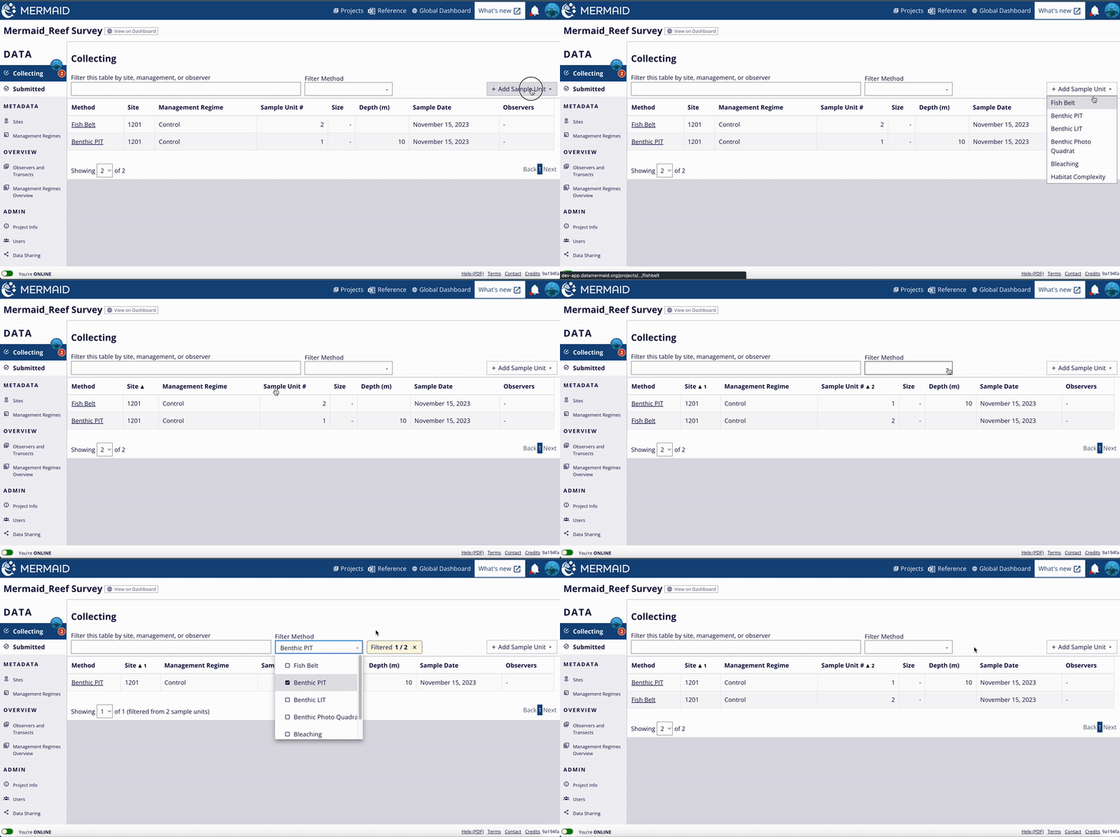
The red number next to the “Collecting” tab in the lefthand menu indicates the number of records you have collected and saved but not yet submitted. The search bar allows you to filter the records by site name, management regime, or observer name. Use the "Filter Method" button to filter based on the method. It allows users to filter in multiple ways and show the total sample unit(s) using the chosen method(s) next to the filter button. Click on the "x" symbol to remove all filters applied. Click on the table headers to sort based on your preference.

The Collecting page

Filter data based on the method using the "Filter Method" button and sort data by clicking the header(s).

Only users with ‘Collector’ or ‘Administrator’ roles can collect and submit new observations; ‘Read-only’ users cannot collect sample units.

A sample unit requires validation prior to submission. Validation will ensure that all data in a sample unit are correct. If not, an error or warning will appear on top of the page and next to the issue that need to be resolved.

Observations can be added both online and offline, but they can only be validated and submitted when connected to the internet.

MERMAID Version 2 also provides an improved experience to record data using a mobile phone.

The Collecting page

Adding new sites and management regimes

In the lefthand menu you can find "Sites" and "Management Regimes". Here admins and collectors can add a new site or management regime to a project. A site is a unique latitude and longitude, with accompanying attributes; a management regime is the area (including MPAs, OECMs, or open access zones) defined by a set of rules in effect at the time of data collection.

Adding a new site

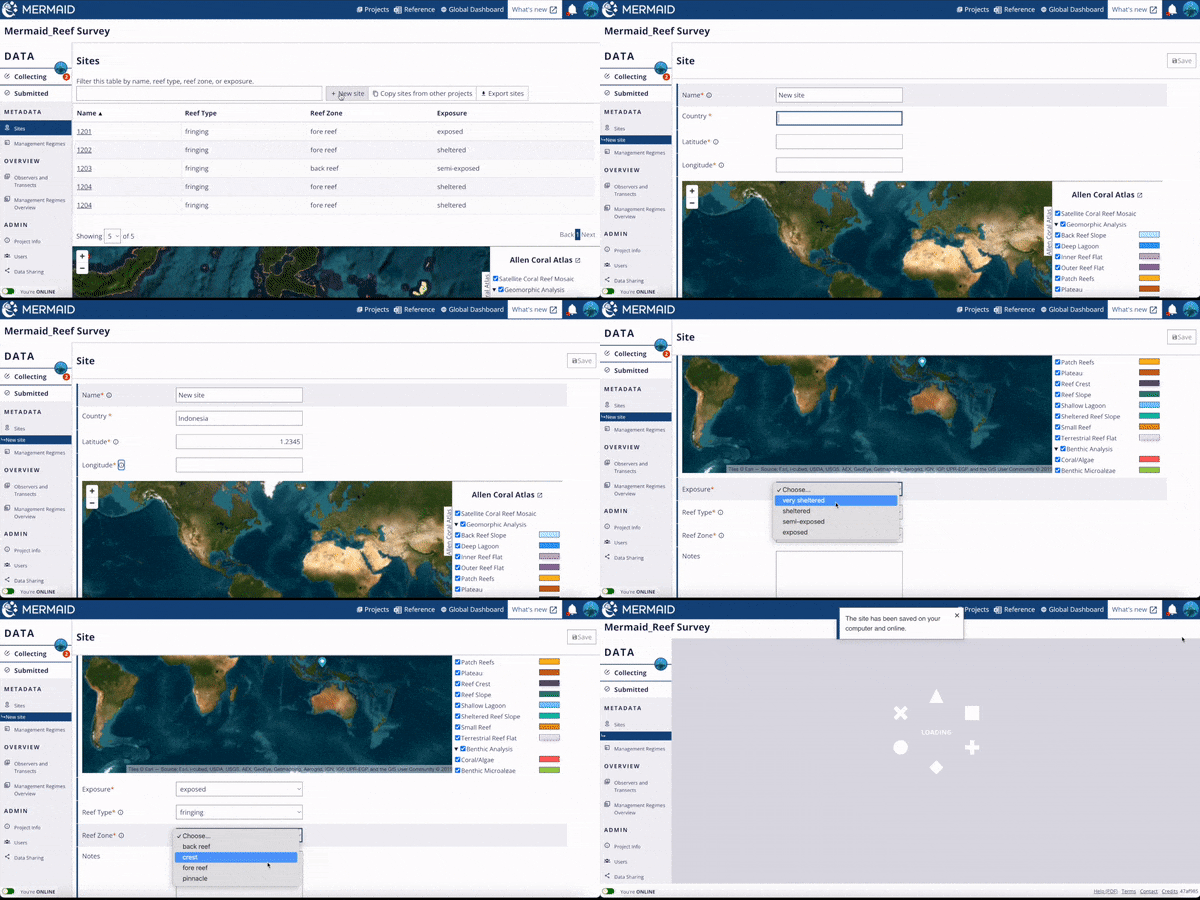
Navigate to the “Sites” tab and select “+ New site” 

A new site requires a name, country, coordinates, and details on the exposure, reef type, and reef zone. The name can be the site’s common name or unique ID. A point symbol will appear on the map below it to show the site location based on the coordinates. The point can be move around to adjust to the right location and the coordinates will follow. When all details have been added the "Save" button will turned on to allow saving the site.

In the “Sites” tab you can choose “Copy sites from other projects” to add existing sites and their metadata from other MERMAID projects.

Adding new sites and management regimes

Adding new site to the project.

A new site created by one user is shared across the project with all other users and available for them to use in observations. Best practice is to plan the sampling sites for your project in advance and add them before going to the field.

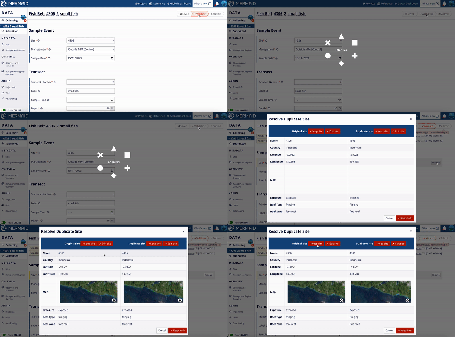
If multiple new sites have identical coordinates, they will be flagged as duplicate sites if used in submitted sample units. In other words, MERMAID will detect duplicate sites only if used in a project. If this happens, for example because multiple team members add the same site while offline, you will see a warning after you hit the "Validate" button next to the "Site" field within a sample unit  that says “Site: Similar records detected”. Click “Resolve” to decide whether to merge the duplicate sites or keep them separate.

Adding new sites and management regimes

Resolve duplicate sites in a project.

A dialog box will show you which sites are considered duplicates. Here you can decide whether to keep one site and merge it with the duplicate sites, or to edit a site and change the metadata to indicate that they actually are separate, unique sites. Unique sites must have different coordinates.


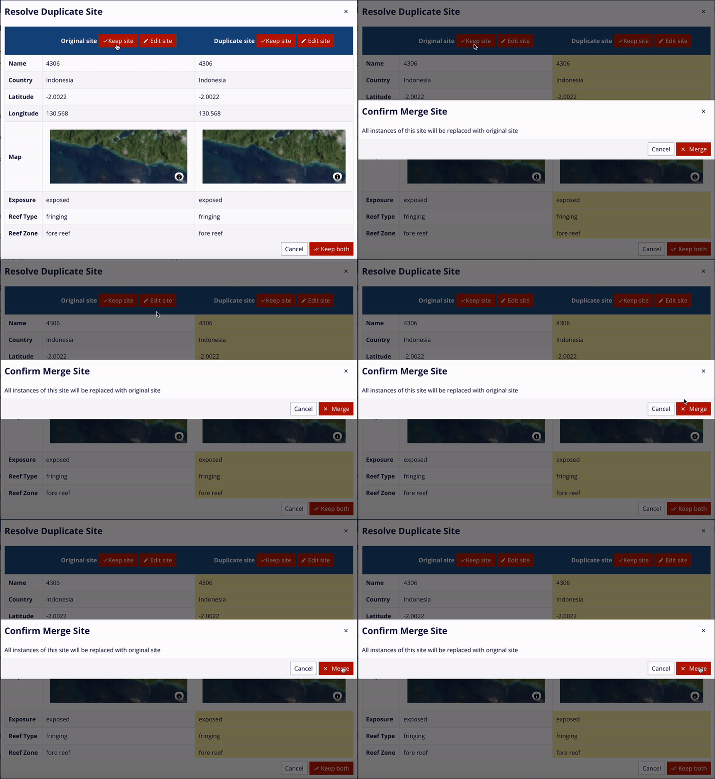
If you choose to keep a site, the site that will be merged with the site you chose to keep will be highlighted in yellow. Select “Merge” to confirm.

Adding new sites and management regimes

Merge duplicate sites.

When sites have been merged, the sites will be updated with the single merged site, and this merged site will automatically be assigned to all sample units that were using the duplicate sites. All observation data will be preserved.

Adding a new management regime

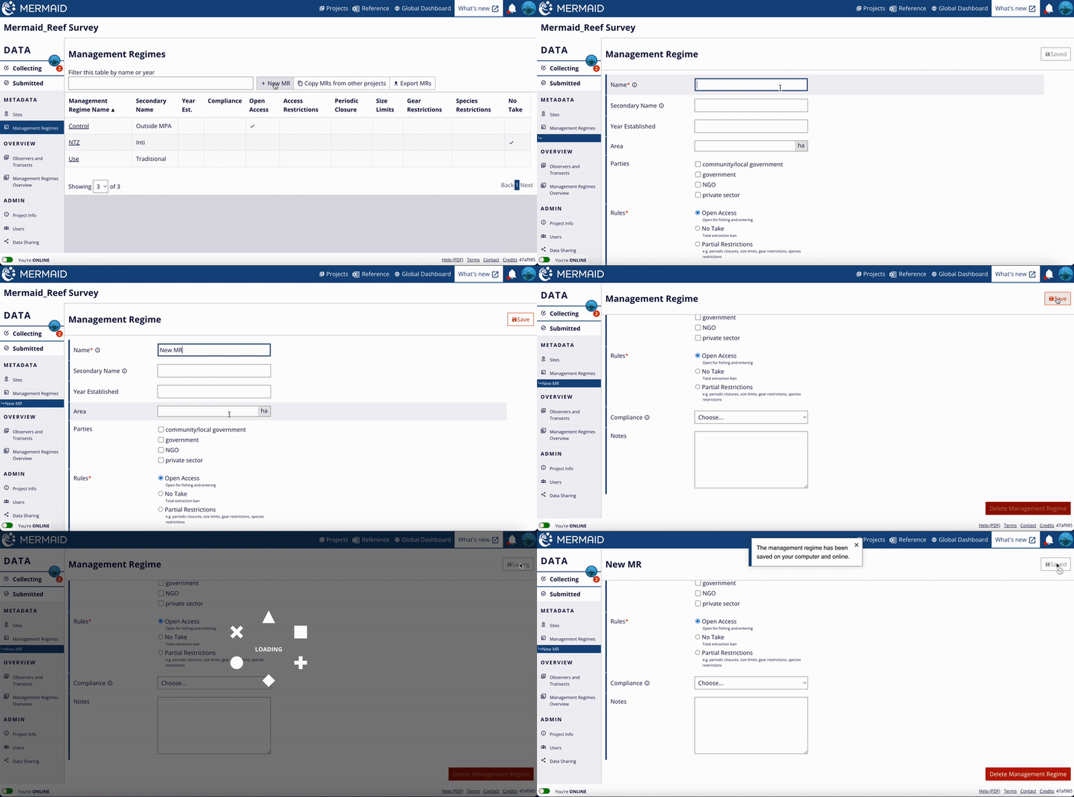
Navigate to the “Management Regimes” tab and select “+ New MR”

Adding new sites and management regimes

Create new management regime in a project.

A new management regime requires a name and at least one rule; all other details are optional. "Open Access" is the default for the "Rules". When you are finished, save the management regime. You can also delete using the “Delete Management Regime” button at the bottom of the page. Only saved management regime can be deleted.


On the “Management Regimes” page you can also choose “Copy MRs from other projects” to add existing management regimes and their metadata from other MERMAID projects. 

A new management regime created by one user is shared across the project with all other users and is available for them to use in observations. Best practice is to know the management regimes within your project in advance and add them while online, before going to the field. Management regime details can be edited after creation if needed.

Multiple management regimes with identical names will be flagged as duplicate management regimes. If this happens, you will see a warning next to the "Management" filed that says “Another Management Regime is similar to this one”.

These management regimes can be merged or kept separate. Click “Resolve” button to decide whether to merge the duplicate management regimes or keep them separate.

Adding new sites and management regimes

A dialog box will show you which management regimes are considered duplicates. Here you can decide whether to keep just one management regime or to edit a management regime and change the metadata to indicate that they actually are separate, unique management regimes. Unique management regimes must have different names.

Adding new sites and management regimes

If you want to keep just one management regime, select the “Keep MR” button. The duplicate management regime(s) that will be merged with the management regime you choose to keep will be highlighted in yellow. This merged management regime will now be assigned to all sample units that had been associated with the duplicate management regime. All observation data will be preserved. If you want to keep both management regimes, select “Keep both”.

Entering a transect

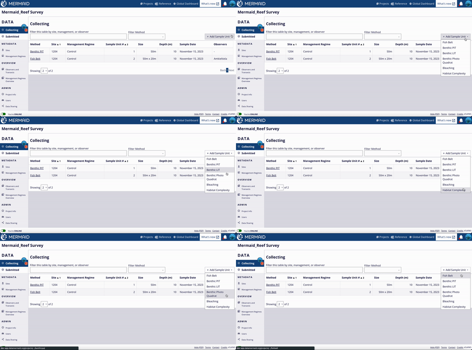
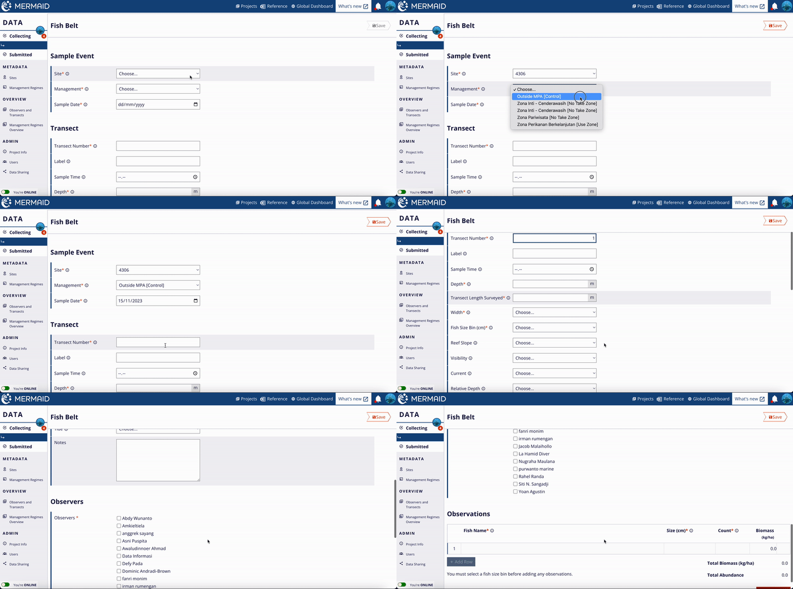
When you’re ready to enter new data for a project, click “+ Add Sample Unit” at the top right of the Collecting page and select a method.

There are six methods available in MERMAID: fish belt transect, benthic point intercept (PIT) transect, benthic line intercept (LIT) transect, benthic photo quadrat transect, bleaching quadrat collections, and habitat complexity transect. These transects are similar to methods described in the Coral Reef Monitoring Protocol for Assessing Marine Protected Areas (Ahmadia et. al 2013) (Appendix 2). The benthic photo quadrat transect currently stores your photo identification results only. 

Entering a transect

There are six methods available in MERMAID.

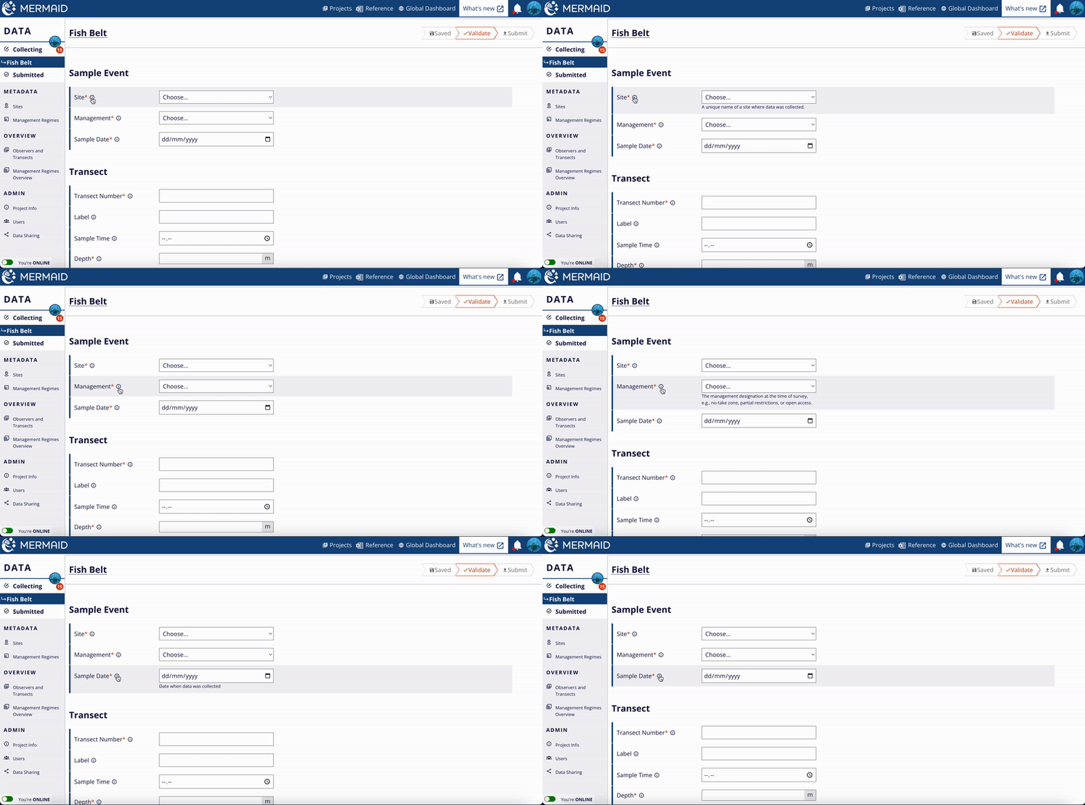
After selecting a method, you must fill in all required fields, marked with a red asterisk. Sites and Management Regimes that you added previously will appear in the dropdowns. A helper text is also availaible to all input fields. You can view this feature by clicking the info icon next to any relevant field. Each will have its own explanation, including text-filling examples.

Entering a transect

Use the show and hide feature for the helper text. This approach applies to all methods in MERMAID.

Optional transect information includes label, sample time, reef slope, visibility, current, relative depth, tide, and any notes.

Entering a transect

When filling in any sample unit, all necessary information (shown with an asterisk symbol) cannot be empty.

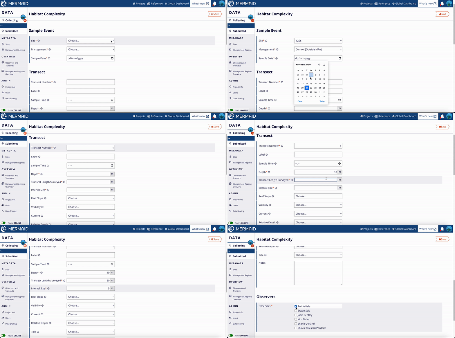
Each transect requires at least one ‘observer’, defined as a person who collected transect observations. This is a required field, and you can choose from the available list of users associated with your project. To remove an observer, uncheck the box next to the observer's name.

Entering a transect

Choose an observer by clicking the checkbox next to the observer's name.

You can save a transect any time, online or offline. A disabled Save button indicates that no data have changed since the last time you saved the transect.

When online, you can validate and submit the transect. Offline, only the ‘Save’ button will appear.

Deleting a Transect

If you wish to delete a transect, click the "Delete Record" button at the bottom of any unsubmitted Sample Unit in Collecting. This will permanently remove the record and its observations from MERMAID, so be sure that you want to remove it before confirming.

Sample unit types

Fish belt transect

Assess reef fish populations by recording the size and abundance of fish along a 'belt' transect of a specific width and length

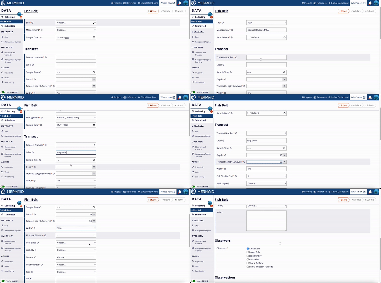
In MERMAID, fish belt transects require users to specify the length of the surveyed transect (meters), and the total width of the surveyed transect (meters). MERMAID users can choose their values to estimate the total transect area surveyed for their biomass calculations. E.g., a transect of 50 m length x 5 m total width = 250 m^2 area, or 0.025 ha. 

Fish belt transect

MERMAID also requires users to enter a transect number (e.g., 1, 2, etc.) to keep track of replicate transects. Users can add more text information to the optional 'label' field if necessary, e.g., 'long swim transect'. In addition, MERMAID users can select how fish sizes are estimated underwater. Typically, scientists use  1cm, 5cm, or 10cm size bins. This provides information on whether a fish was observed as: 

  • 26 cm (1 cm bin)

  • 25-30 cm (5 cm bin)

  • 20-30 cm  (10 cm bin)

For all fish larger than 50+ cm, select the '50+cm' bin and enter in the exact size estimate in cm. 

Additionally, there are other size bin groupings that can be selected: 

  • AGRRA: 0-5cm, 6-10cm, 11-20cm, 21-30cm, 31-40cm, 40-50cm, 50+cm

  • WCS India: 0-5cm, 5-10cm, 10-20cm, 20-30cm, 30-50cm, 50+cm

Fish belt transect

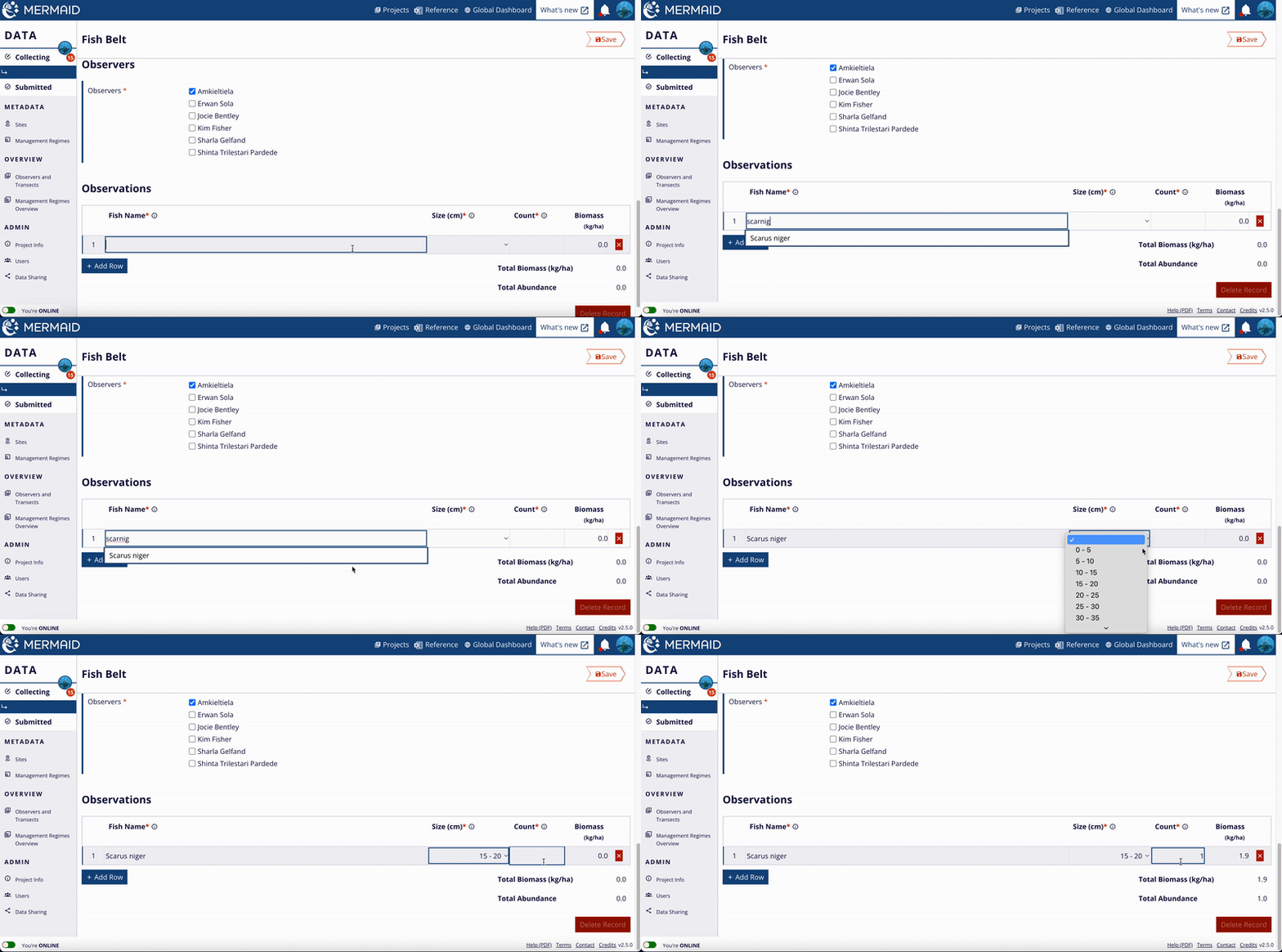
Entering transect and observations information.

After entering information about the transect and observers, you can enter in your reef fish observations. Note: Once you have selected a fish 'size bin' and entered data, you are not able to change the size bin without deleting your observations. 

Fish belt transect

Entering observation data to the Observation Table. Use the predictive feature to type faster.

To enter a reef fish name, simply type any three letters of an observed fish family, genus, or species, MERMAID will provide a predictive dropdown with names. This ensures all spelling is correct and consistent. Select the fish family, genus, or species to use for an observation by using the ‘up’ or ‘down’ arrow keys or entering more letters so that there is only one choice and press the Enter or Return key to select a name.

MERMAID's fish names use the World Register of Marine Species (WORMS) taxonomy standard. Before proposing new fish species to the MERMAID team, check the species is an accepted standard on WORMS. Biomass coefficients are linked in from FishBase Bayesian length-weight coefficients in order to calculate biomass 'on the fly' as you enter each observations. Not seeing your biomass estimates? Double check that you have entered a transect length and width (so MERMAID knows the transect size that you are estimating biomass). 

To avoid common errors, MERMAID will flag the following warnings and errors:

  • Warning: Total biomass less than 100 kg/ha or greater than 2,000 kg/ha

  • Warning: Total fish count less than 10

  • Warning: Total observations less than 5

  • Errors: Missing metadata information (e.g., depth, transect length or width, observers, etc.)

Be a sailfish: enter your data at top speeds! 

Did you know that the Indo-Pacific Sailfish (Istiophorus platypterus) is the fastest fish in the world with swimming speeds at >110 km/hour? MERMAID helps you be a sailfish too and enter your data at top speeds! 

How? Use the ‘tab’ and 'return' keys and your 'up' and 'down' arrows on your keyboard to quickly enter your observations.  After typing a few letters and selecting your observed fish with the 'up' or 'down' arrow keys on your keyboard, use the 'tab' key to move across to the size and count columns, then type or select your entry (still on your keyboard). At the end of a row, press 'tab' at the end of a row to duplicate the fish species. This is helpful if you are entering on row of Acanthuridae 5-10cm bin observations, then press 'tab' to enter Acanthuridae 10-15cm observations, for example. Or maybe then you see a sailfish! Press 'return' to type in 'Istpl' and use the down arrow key to select Istiophorus platypterus.

Benthic point transect (PIT)

The benthic point intercept transect (PIT) records observations of benthic cover at regular intervals along a transect.

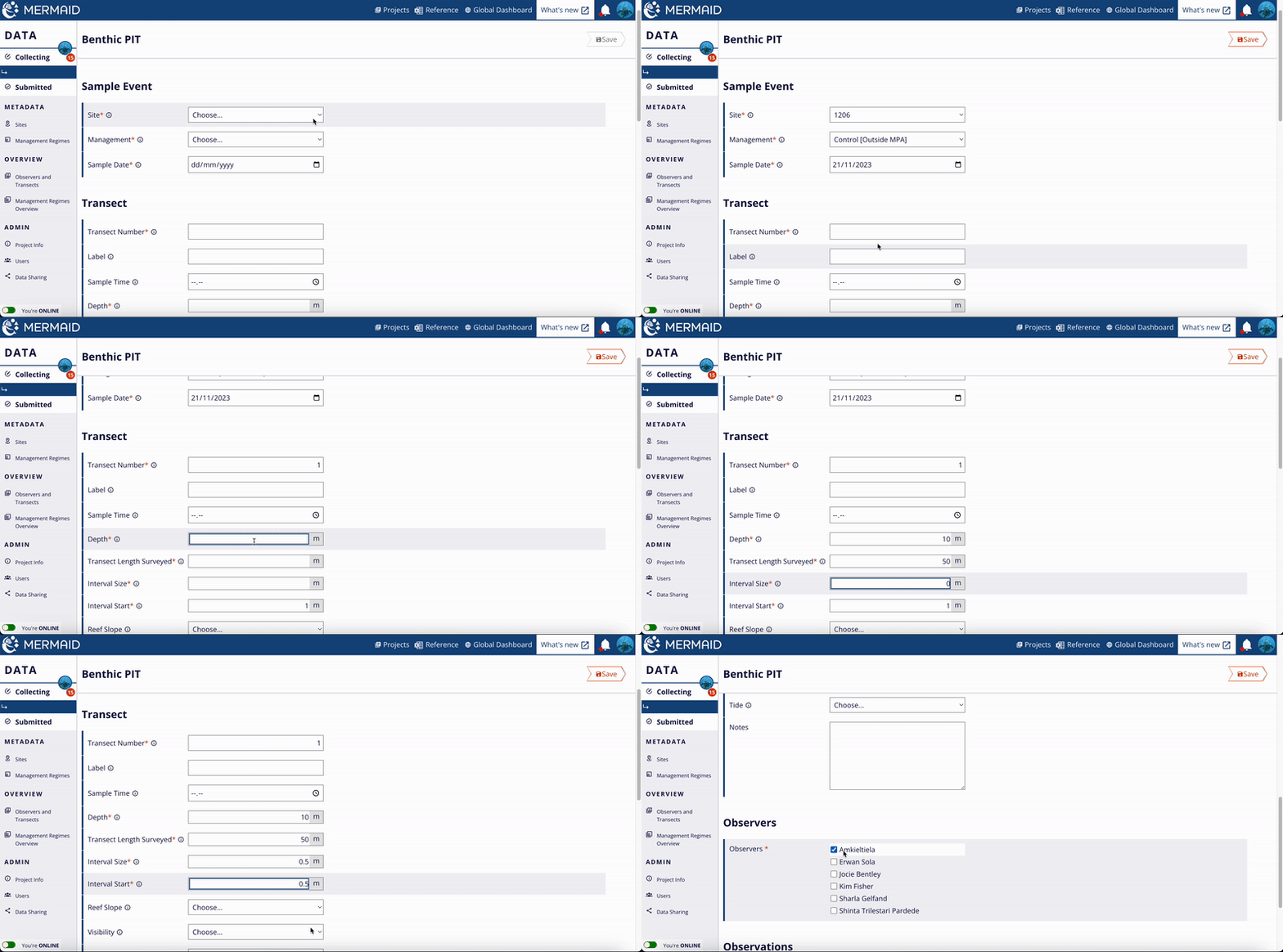
Each transect requires a transect number, depth, the surveyed transect length (m), the interval between point observations (m), and the interval point where you start to record your data (m). For example, points counted every 50 cm can be entered as 0.5m in the “Interval size” field.

Benthic point transect (PIT)

Image: Komaruddin/WCS Indonesia

Benthic point transect (PIT)

Entering the transect and observations information.

Enter the benthic attribute observed at each point at the bottom of the page.

Benthic point transect (PIT)

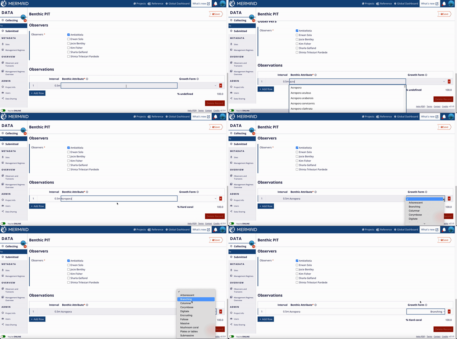
Entering observation data to the Observation Table. Use the predictive feature to type faster.

After typing any three letters of an observed benthic attribute, MERMAID will provide a predictive dropdown with names. This ensures that all spelling is correct and consistent. Select the benthic attribute by using the ‘up’ or ‘down’ arrow keys on your keyboard or with your mouse, or entering more letters so that there is only one choice, and then pressing the 'Enter'/'Return' or 'Tab' key to select a name. Growth forms can be selected from the dropdown list or predicted by typing.

Available benthic attributes can be found using the “Reference” icon at the header of any page. New benthic attributes can be proposed to the MERMAID science team for approval and addition.

The number of rows should equal the total number of expected points based on your transect length and interval size. You will receive a warning if the number of entered rows does not match this.

The percent cover of each benthic category along the transect will automatically be calculated and displayed at the bottom of the rows. All benthic attributes belong hierarchically to a small number of top-level benthic categories commonly used for analysis, such as "hard coral".

NAVIGATION TIP

Use the ‘Tab’ key to move across to the attribute and growth form columns. At the end of the row, press 'Enter'/'Return' to create a blank row and add a new benthic attribute observation. Press the 'Tab' key at the end of the row to duplicate the benthic attribute in the next row.

Benthic line transect (LIT)

The benthic line intercept transect (LIT) records observations of benthic cover length along a transect.

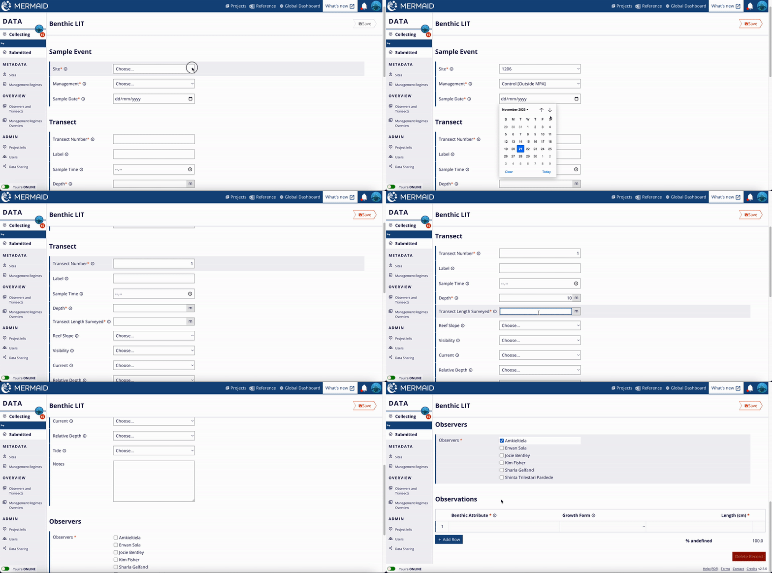
Each transect requires a transect number, depth (m), and the surveyed transect length (m).

Benthic line transect (LIT)

Entering transect and observations information.

Enter the benthic observations from the transect at the bottom of the form.

Benthic line transect (LIT)

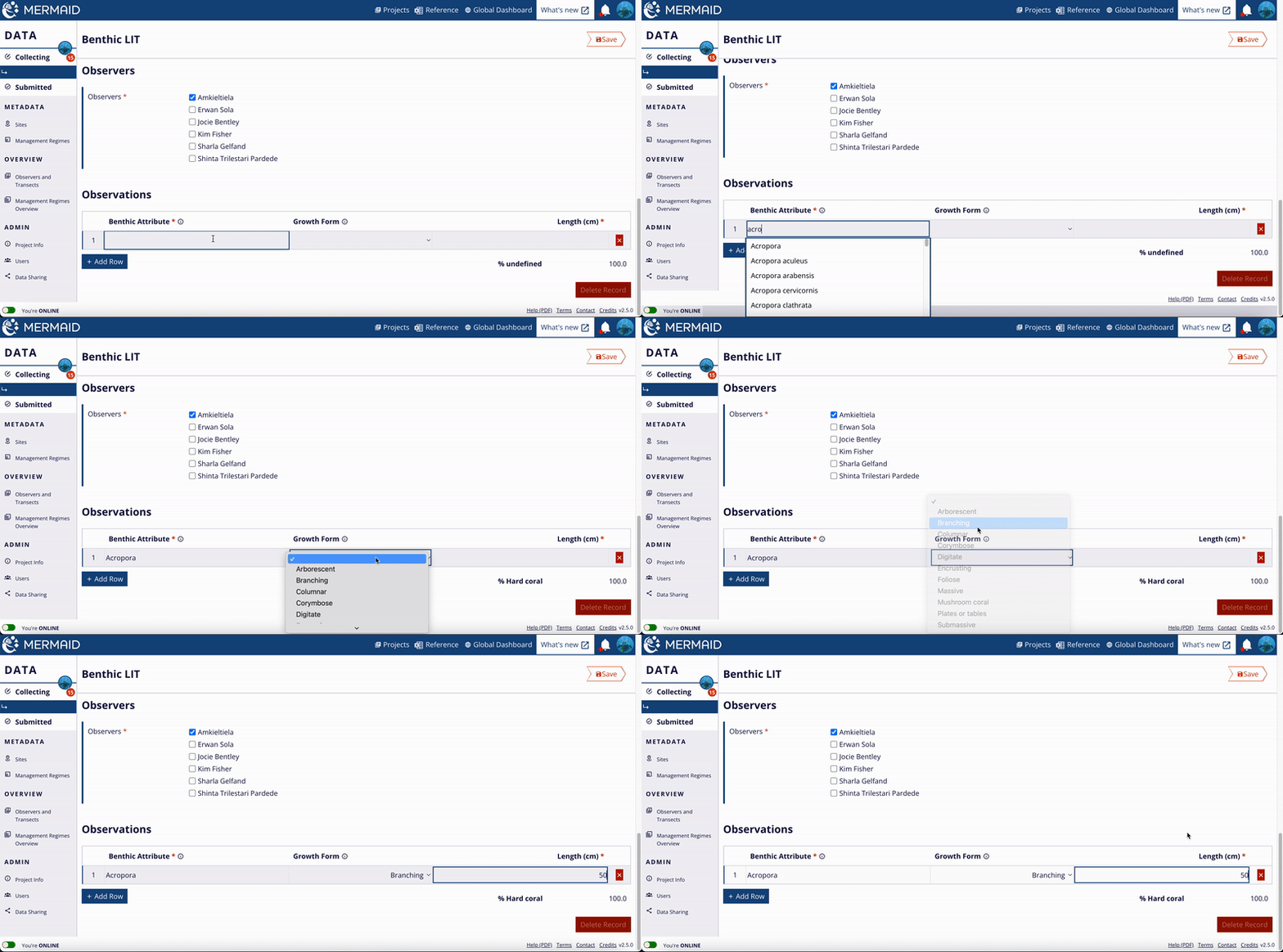
Entering observation data to the Observation Table. Use the predictive feature to type faster.

After typing any three letters of an observed benthic attribute, MERMAID will provide a predictive dropdown with names. This ensures that all spelling is correct and consistent. Select the benthic attribute by using the ‘up’ or ‘down’ arrow keys on your keyboard or with your mouse, or entering more letters so that there is only one choice, and then pressing the 'Enter'/'Return' or 'Tab' key to select a name. Growth forms can be selected from the dropdown list or predicted by typing.

Available benthic attributes can be found using the “Reference” icon at the header of any page. New benthic attributes can be proposed to the MERMAID science team for approval and addition.

The sum of the observation lengths entered should equal the total transect length. You will receive a warning if not.

The percent cover of each benthic category along the transect will automatically be calculated and displayed at the bottom of the rows. All benthic attributes belong hierarchically to a small number of top-level benthic categories commonly used for analysis, such as "hard coral".


NAVIGATION TIP

Use the ‘Tab’ key to move across to the attribute, growth form, and length columns. At the end of the row, press 'Enter'/'Return' to create a blank row and add a new benthic attribute observation. If the same attribute is observed but with a different length, press the ‘Tab’ key at the end of the row to duplicate the benthic attribute in the next row.

Benthic Photo Quadrat

This sample unit records the results of classified photo quadrat images.

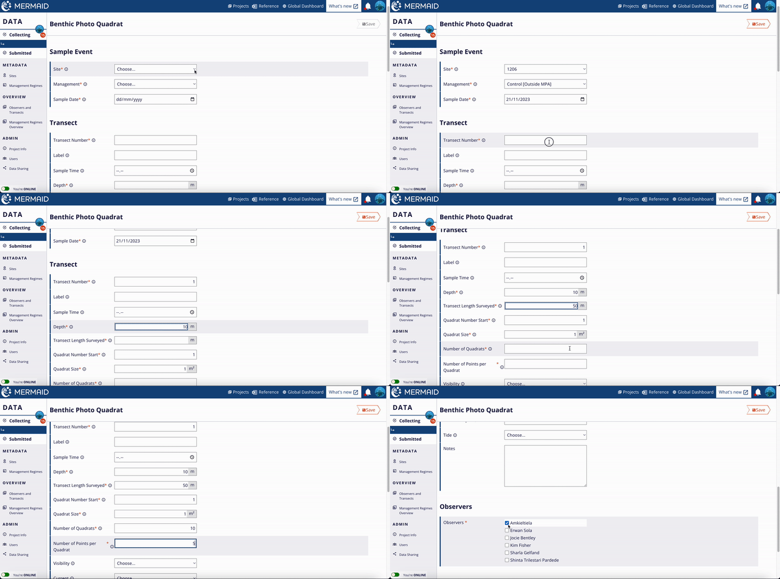
Each transect requires a transect number, depth (m), surveyed transect length (m), the starting quadrat number, the quadrat size (m2), the number of quadrats, and the number of points per quadrat.

Benthic Photo Quadrat

Entering transect and observations information.

Enter the photo identification results from the photo quadrat observations at the bottom of the form.

Benthic Photo Quadrat

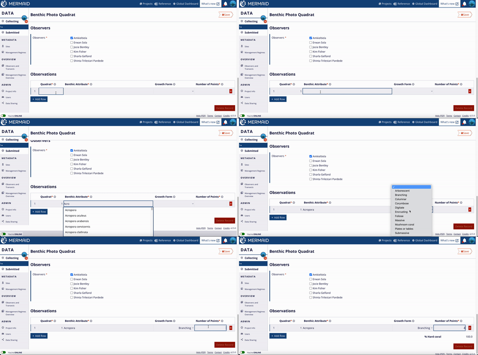
Entering observation data to the Observation Table. Use the predictive feature to type faster.

Each observation must record the total number of points identified as a particular benthic attribute in a particular photo quadrat.

After typing any three letters of an observed benthic attribute, MERMAID will provide a predictive dropdown with names. This ensures that all spelling is correct and consistent. Select the benthic attribute by using the ‘up’ or ‘down’ arrow keys on your keyboard or with your mouse, or entering more letters so that there is only one choice, and then pressing the 'Enter'/'Return' or 'Tab' key to select a name. Growth forms can be selected from the dropdown list or predicted by typing.

Available benthic attributes can be found using the “Reference” icon at the header of any page. New benthic attributes can be proposed to the MERMAID science team for approval and addition.

The sum of the points in the observations entered for that quadrat must equal the total number of points entered at the transect level above.

The percent cover of each benthic category along the transect will automatically be calculated and displayed at the bottom of the rows. All benthic attributes belong hierarchically to a small number of top-level benthic categories commonly used for analysis, such as "hard coral".

NAVIGATION TIP

Use the ‘Tab’ key to move across to the attribute, growth form, and number of points columns. At the end of the row, press 'Enter'/'Return' to create a blank row and add a new benthic attribute observation. Press the 'Tab' key at the end of the row to duplicate the benthic attribute in the next row.

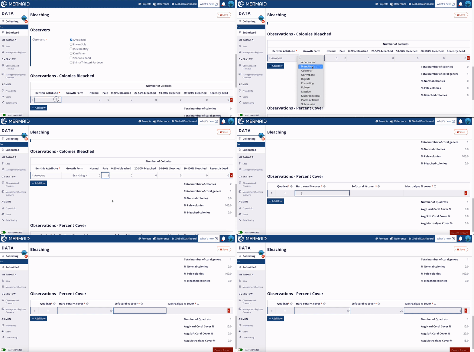
Coral bleaching

This rapid assessment field method can be used to quantify coral bleaching for different genera of hard corals.

In this rapid assessment field method, the sample unit is a collection of quadrats observed for coral bleaching on a single dive/snorkel. The method is described in detail here.

First, observers choose a consistent quadrat size (typically 1 to 2 m2) to use on the survey. During a survey, an observer records information from a set of quadrats, typically ~15-20 quadrats. Within a quadrat, an observer first counts the number of coral colonies for each hard coral genus and classifies each colony within 7 categories of bleaching severity: normal, pale, 0-20% bleached, 20-50% bleached, 50-80% bleached, 80-100% , and recently dead. After recording the coral colonies, the observer then visually estimates the cover of three main benthic groups within the quadrat: hard coral, macroalgae, and soft coral. Then, the observer swims a set distance (e.g., 10 fin kicks) to begin the next quadrat. 

Coral bleaching

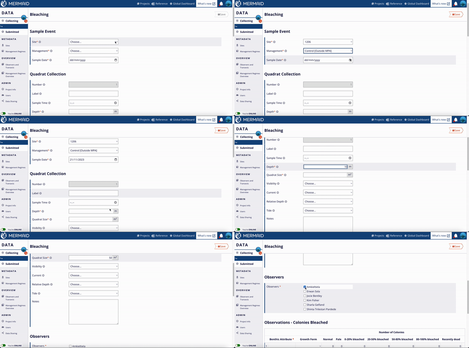
Entering transect and observations information.

In MERMAID, observations from the surveys are recorded in 2 sections. The 'Colonies Bleached' section records the total number of colonies in each bleaching category for each genus. The 'Percent Cover' section records the % cover of hard coral, macroalgae, and soft coral for each quadrat. 

Coral bleaching

Entering observation data to the Observation Table. Use the predictive feature to type faster. The bleaching observation is divided into two sections, i.e. 'Colonies Bleached' section and 'Percent Cover' section.

NAVIGATION TIP

Use the 'Tab' key to move across the colonies bleached and percent cover columns. At the end of the row, press 'Enter'/'Return' key to create a blank row to add the next complexity observation. If the same bleaching or percent cover is observed at the next interval, press the 'Tab' key at the end of the row to duplicate.

Habitat complexity

This transect records observations of benthic habitat complexity on a scale of 0 to 5, based on the methodology proposed in Wilson et al. (2007) and described in Darling et al. (2017) and Gurney and Darling (2017) (Appendix 2).

To enter a habitat complexity transect, you will need to provide a transect number, depth (m), the surveyed transect length (m), and the interval between complexity observations (m). For example, assessing complexity every 5 m can be entered at ‘5 m’ in the “Interval size” box.

Habitat complexity

Entering transect and observations information.

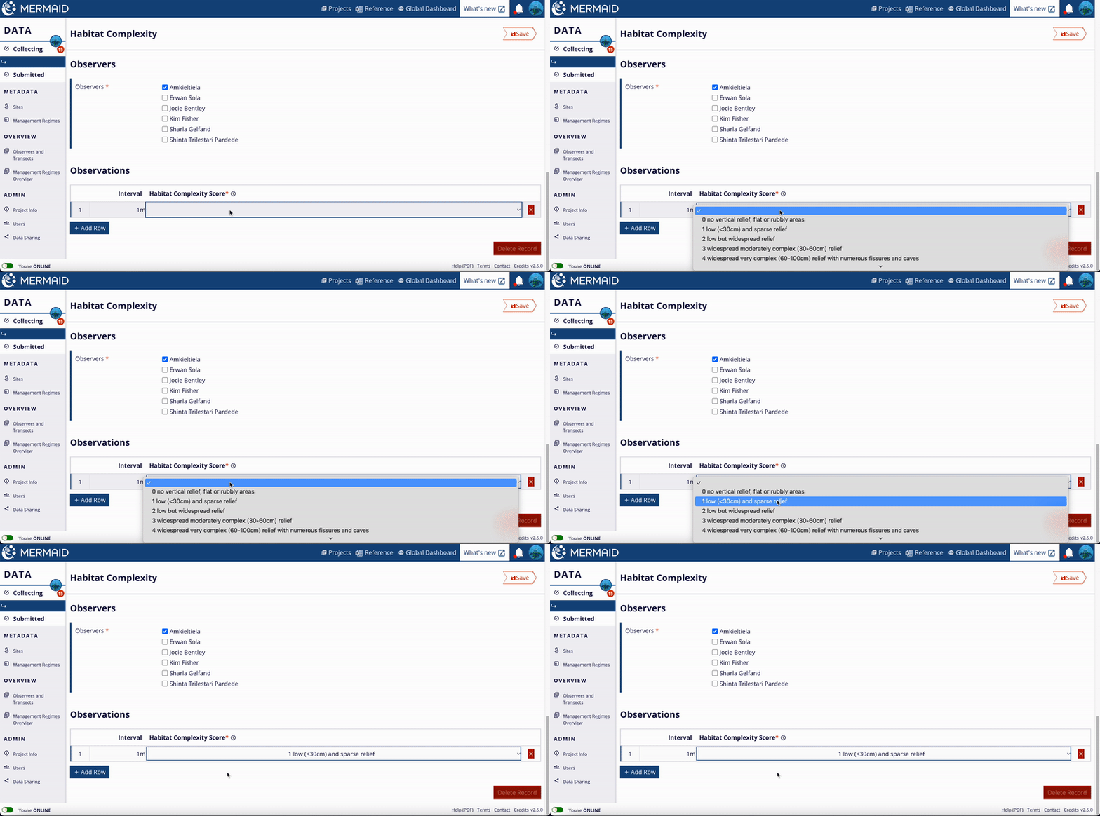
Enter the habitat complexity score at each interval at the bottom of the page. You must have as many rows of observations as you do intervals in the transect length.

Habitat complexity

Entering observation data to the Observation Table.

NAVIGATION TIP 

Use the 'Tab' key to move across the interval and habitat complexity score columns. At the end of the row, press 'Enter'/'Return' key to create a blank row and add the next complexity observation. If the same habitat complexity is observed at the next interval, press the 'Tab' key at the end of the row to duplicate the previous row.

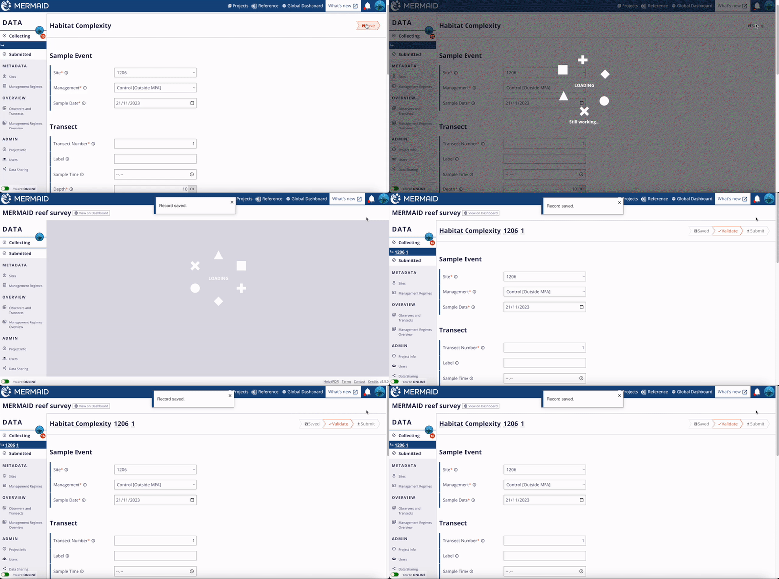
Saving a transect

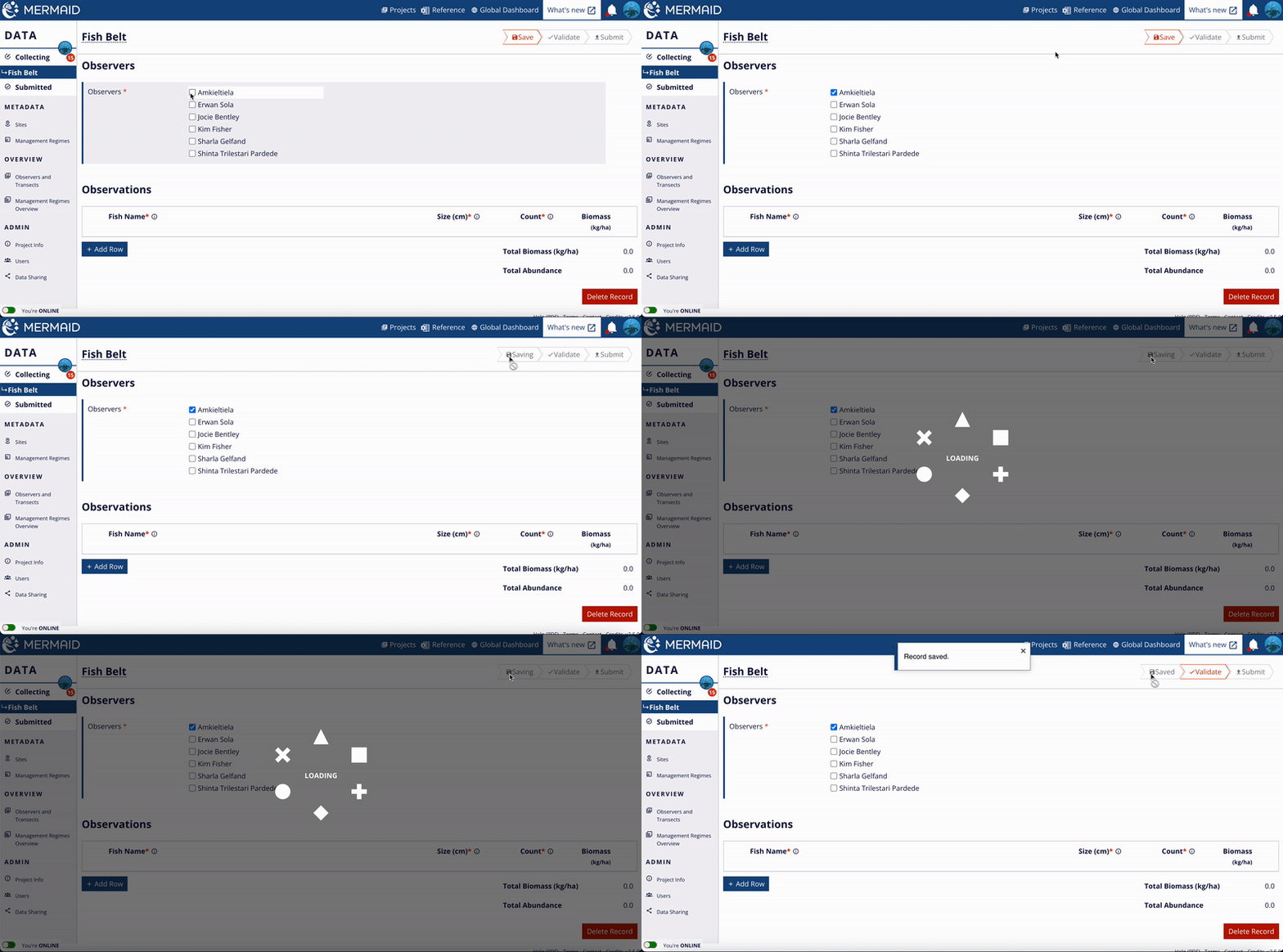
Once you enter any new information into a transect, you can save it using the button in the upper right corner of the page. 

The save button is bright red when there is new information to be saved. If the button is gray and says “Saved”, you have already saved the transect and there is no new information to be saved.

Saving a transect

Click the red 'Save' button to save a sample unit. Once saved, the button will greyed out and read 'Saved'.

After saving, you can always return to the transect to add or change data and information and resave.

If you try to navigate away from a page with unsaved information, you will see a warning on the screen that you have unsaved data – choose “Cancel” to stay on the transect and save; choose “Ok” to leave the transect unsaved.

Once you validate and successfully submit your transect, you can no longer edit it. If you need to edit a submitted transect, a project admin must un-submit it; if you are not the project admin, they will then need to transfer it to you for editing.

All sample units are always saved on your computer. Any time you are online, MERMAID also saves to a backed-up database in the Cloud.

Validate and submit data

After your data has been saved, it can be validated. Validation is the “proofreading” of the sample unit information and observations. This is where mistakes and outliers are caught and brought to your attention to correct. Site and management regime validations are checked only against submitted sample units. A reminder of why a sample unit cannot be submitted is shown under the Submit button to help you address problems more quickly.

Validation can only be done online.

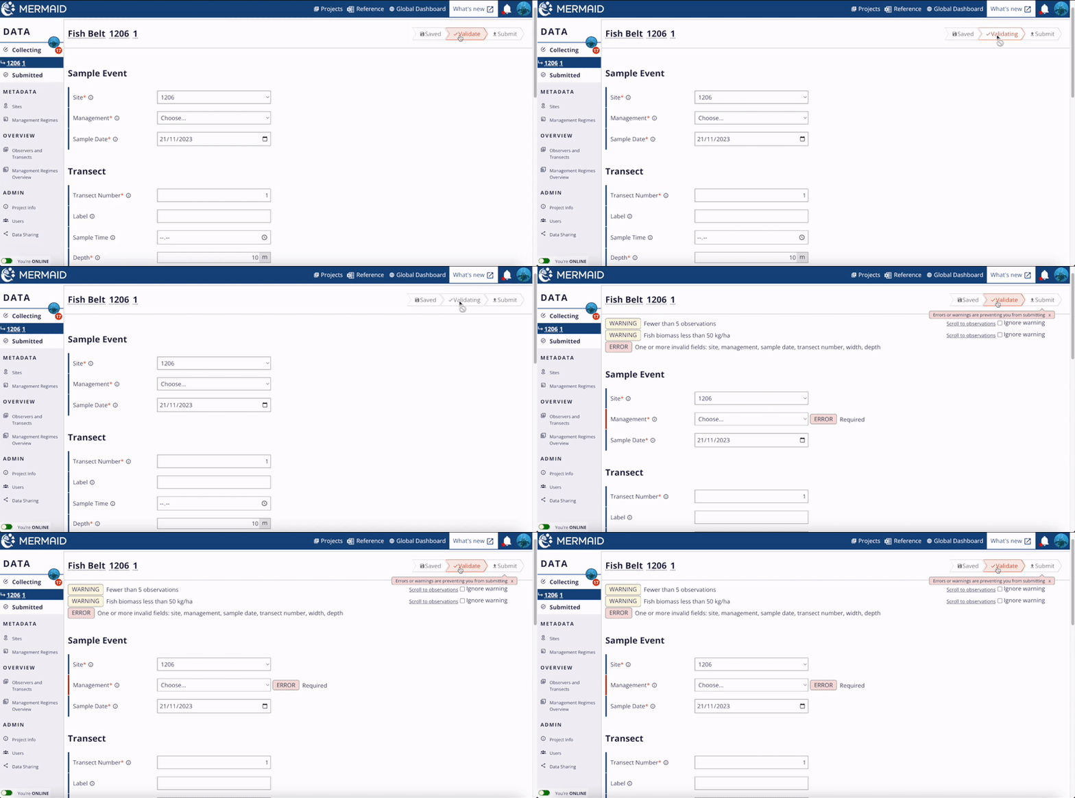
After saving a transect, click the activated red “Validate” button to validate your transect.

Validate and submit data

Validating a sample unit can only be done when connected to the internet.

After successfully validating a transect and resolving any errors or warnings, the Validate button will be grayed out and the Submit button will be activated in red.

After validating, you will receive one of the following results:

A. Success!

Nice work, your sample unit was validated successfully! There are no errors with the data and it is ready to submit.

B. Warnings

Validate and submit data

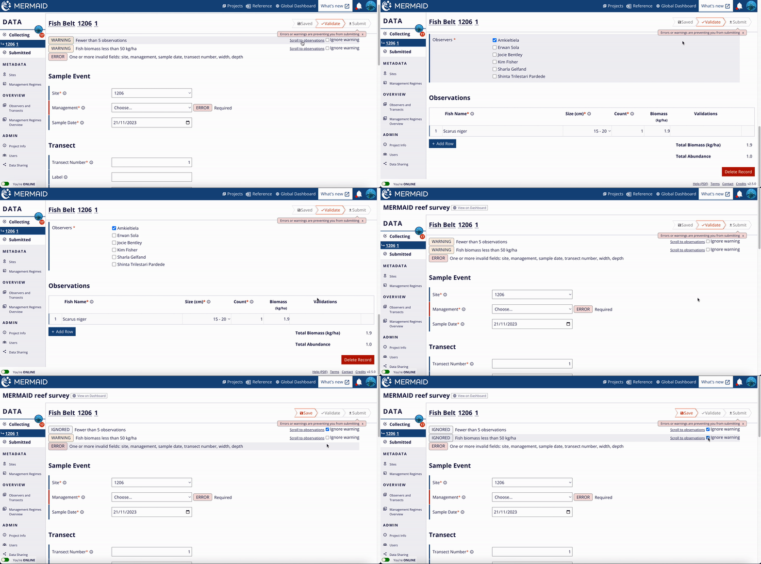
Warning messages can be either ignored or solved by correcting the data in the field.

A yellow warning will appear at the top of the page or by and individual form field if MERMAID identifies a potential issue in your transect information. Warnings are validations that identify entered data that are possible, but unusual.

You can decide whether each warning can safely be ignored for your data. If the issue resulted from a data entry mistake, you can correct the data in the field, or in some cases by clicking a “Resolve” button to open a dialog where you can add or change the information. Click “update” to incorporate your changes into the transect. You can also navigate to fields with issues by clicking 'Scroll to observations' next to the warning.

After addressing warnings, resave the transect and validate again. Repeat the process for any additional warnings that are identified. If you don’t believe a warning is accurate for your transect, you can disregard it by clicking the 'Ignore warning' checkbox next to the warning.

C. Errors

Validate and submit data

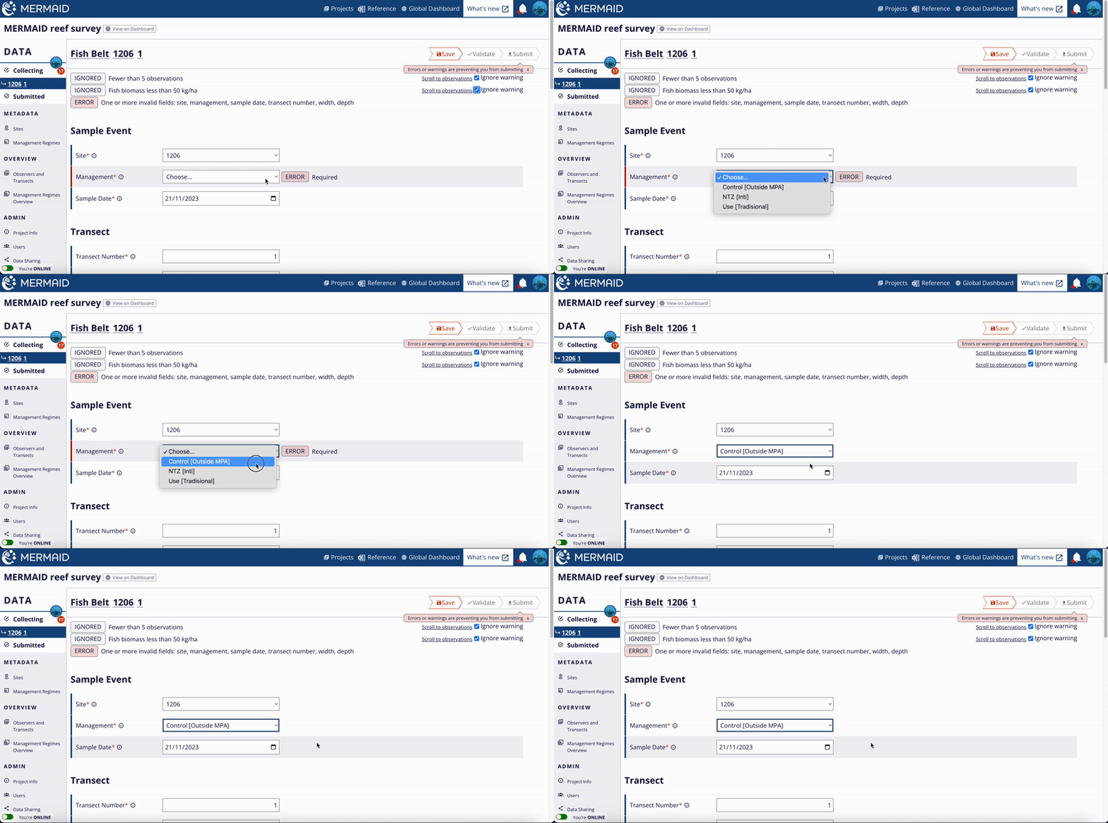
Errors can not be ignored and must be resolved before a sample unit can be submitted.

A red warning message will appear if MERMAID identifies an error in a sample unit’s information or observations. Errors must be resolved before a transect can be submitted; they cannot be ignored. To address each error, scroll down to the field that has the 'ERROR' notice and directly change the information.

After resolving all errors, resave the transect and validate again. Repeat the process for any additional errors that are identified, until all 'ERROR' notices have disappeared.

D. Submit data

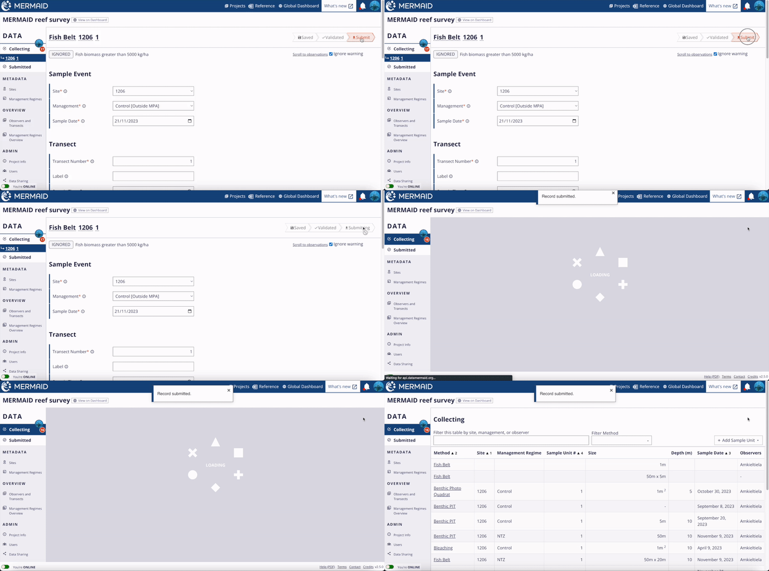
When you are finished entering data for a sample unit and have resolved all Errors and Warnings, you can Submit the sample unit.

After submitting data, admin users can still edit the transect or return a transect to the observer, so as a collector, make sure your data are finalized and clean before submitting! Submitting data can only be done when online.

To submit data, select the red button in a validated transect that says “Submit”.

Validate and submit data

Submit a sample unit by clicking the 'Submit' button after all errors and warnings addressed.

Submitting data moves it from the "Collecting" page to the "Submitted" page. This shares your observations with the other users in the project (and depending on Data Sharing settings, potentially with the world). Within the “Submitted” page, admins can edit or delete transects or return them to their original observers for further editing.

If you are a read-only member on a project you can see data once it has been submitted and you can export it, but you cannot edit this data while it is in MERMAID.

You can also view your submitted data per project in the MERMAID Dashboard directly from the Collect app. Simply click on the icon 'View on Dashboard' next to the project name to navigate to the dashboard.

Validate and submit data

Manage your data

Manage your data

The Observers and Transects page helps you to easily identify who to chase for unsubmitted sampe unit(s).

Manage your data

The Management Regimes Overview table helps you to make sure that all sites have the correct management regimes.

Upload spreadsheets

Good news! You can now upload your existing data or 'legacy data' directly to MERMAID using the mermaidr R package.

If you are new to MERMAID but have data from past surveys in other formats, you may be trying to figure out how to import your legacy data into MERMAID. The mermaidr package is a way to ingest your old data into MERMAID. 

Ingesting data should only be used for legacy data. For an ongoing project, it is easier to use the app directly.

Upload spreadsheets

The ingestion workflow.

Steps for ingestion using the mermaidr package:

  1. Create a project in MERMAID with sites, management regimes, and users added.

  2. Adjust your data format to the MERMAID template. You can download the template for each method using the mermaid_import_get_template_and_options function from the mermaidr package. More information on how to use it can be seen here.

  3. Ensure the mandatory fields are filled. Mandatory fields include an asterisk (*) sign in the column name.

  4. Check each field to make sure it matches allowed field options for importing data for a given method. To check each field, use the mermaid_import_check_options function from the mermaidr package. More information and example on how to use it can be seen here. A field that matches will produce a green check sign.

  5. After all fields have passed the checking process, you can import your data using the mermaid_import_project_data function from the mermaidr package. Detailed information and an example can be seen here.

All ingested data will appear on the Collecting page. These data will need to go through the regular validation and submission process. For an example how to ingest your legacy data using the mermaidr package, head to the ingesting fishbelt data example.

Unsubmitted ingested transects appear on the Collecting page of the user who did the ingesting. To transfer unsubmitted sample units to another user, a project admin can use the project's Users page.

Upload spreadsheets

Ingested data will appear in your collecting page and will be shown on the Project Page under the COLLECTING tab. The number in the red circle shows the number of sample units in your collecting page, while the number without the red circle show the total unsubmitted sample units in a project.

We have also prepared below a video to walk you through the ingestion steps, using the historical fishbelt data as an example. 

Ingesting historical fish belt data into MERMAID using the mermaidr package.
library(ggplot2)

Use your data

Export to XLSX

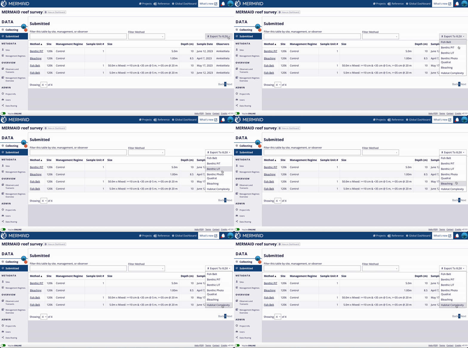
Submitted transects can be exported to a tabular format in a .xlsx file for further analysis by clicking the ‘Export To XLSX’ button. Use the 'Filter Method' button next to the search bar to filter the submitted transects based on method. The total transects using the chosen method(s) will appear next to the filter button.

Data can only be exported when online and after transects have been submitted. Data in a test project will not be exported.

Make sure that the project is not a test project. Select which method you would like to download. All records of each sample unit with the same method will be combined into a single spreadsheet. This will begin downloading a .xlsx to your computer. All user levels (admin, observer, and read-only) can export data from a project.

Export to XLSX

Export submitted sample unit(s) per method by clicking the 'Export To XLSX' button.

To change a project from a "Test Project" to an actual project, click "Data Sharing" in the lefthand menu. Scroll down and uncheck the 'This is a test project' checkbox. Wait approximately 20 minutes for the data to sync with the server, and then you can export your data.

Export to XLSX

Change a project from a "Test Project" to an actual project by uncheck the 'This is a test project' checkbox.

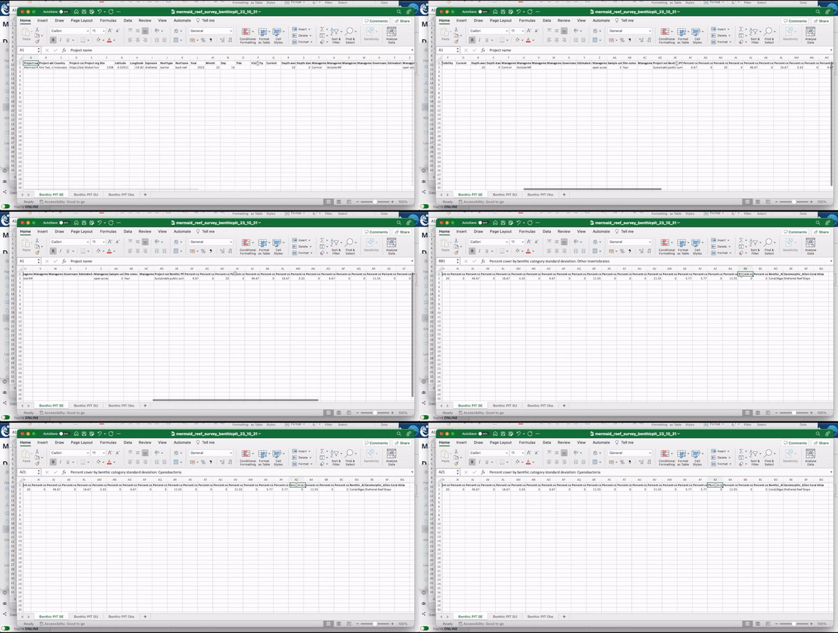
MERMAID also calculates standard deviations corresponding to estimated sample event (site and date) averages. You can find this information in the exported data, under the Sample Event (SE) tab, or by retrieving sample event data using mermaidr, which gives direct access to MERMAID data through R Studio. 

Export to XLSX

After exporting your data, you can find the standard deviation values under the Sample Event (SE) tab.

Questions? You can reach out to us when online via the Contact link at the bottom of any page. An offline (pdf) version of this documentation is also available on the left side of the same area.

public class Main {
  public static void main(String[] args) {
    System.out.println("Hello World");
  }
}
  1. test

SELECT * FROM Customers
WHERE City='Berlin' OR City='München';


x = 5
y = "John"
print(x)
print(y)

import mymodule

mymodule.greeting("Jonathan")

fruits = ["apple", "banana", "cherry"]
for x in fruits:
  if x == "banana":
	continue
	print(x)
library(mermaidr)

test <- read_csv2("test.csv")

R Package

API